Areado geodata
Areado (Minas Gerais) is a populated place; located in Brazil in America/Sao_Paulo (GMT-3) time zone. With population of 10,689 people, there are 1591 cities with bigger population in this country. Compared to other cities in Brazil, 65.7% of cities are located further ↑North; 53.1% of cities are located further →East and 90.3% of cities have lower elevation than Areado. Note1


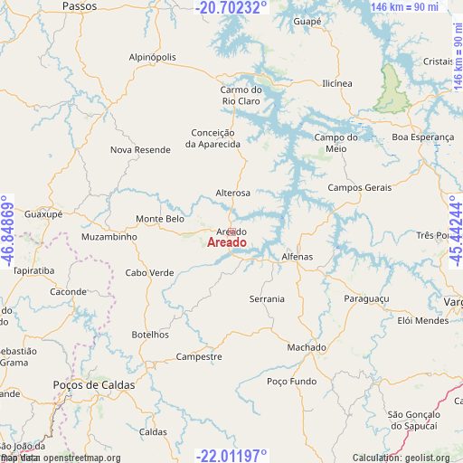
Areado GPS coordinates[2]
21° 21' 30.996" South, 46° 8' 44.016" West
| Map corner | latitude | longitude |
|---|---|---|
| Upper-left | -20.70232°, | -46.84869° |
| Center: | -21.35861°, | -46.14556° |
| Lower-right: | -22.01197°, | -45.44244° |
| Map W x H: | 145.6×145.6 km | = 90.5×90.5mi |
| max Lat: | 2.81972° ⇑65.7% North |
| Areado: | -21.35861° |
| min Lat: | ⇓34.3% South -33.69111° |
| min Long | Areado | max Long |
| -72.89583° | -46.14556° | -32.41083° |
| W 46.9%⇐ | ⇒53.1% E |
Elevation
Elevation of Areado is 819 m = 2687 ft, and this is 438.1 m = 1437 ft above average elevation for this country.
| Max E: |
1603 m = 5259 ft | 9.7% |
| Areado | 819 m 2687 ft | |
| Avg. | 380.9 m = 1250 ft | |
Min E: |
0 m = 0 ft | 90.3% |
See also: Brazil elevation on elevation.city.
Geographical zone
Areado is located in South Torrid zone (between Equator and Tropic of Capricorn). Distance of this Southern Tropic circle is 231.1 km =143.6 mi to South.| Distance of | km | miles | from Areado |
|---|---|---|---|
| Equator | 2374.9 | 1475.7 | to North |
| Tropic Capricorn | 231.1 | 143.6 | to South |
| Antarctic Circle | 5026.3 | 3123.2 | to South |
| South Pole | 7632.2 | 4742.4 | to South |


Nearby cities:
15 places around Areado: (largest is in red/bold)
• Alfenas
22 km =13.7 mi,  110°
110°
• Alpinópolis
60.5 km =37.6 mi,  335°
335°
• Alterosa
12.2 km =7.6 mi,  1°
1°
• Botelhos
40 km =24.9 mi,  220°
220°
• Caconde
55 km =34.2 mi,  249°
249°
• Campestre
40.6 km =25.2 mi,  194°
194°
• Campos Gerais
42.4 km =26.3 mi,  71°
71°
• Carmo do Rio Claro
43.1 km =26.8 mi, 3°
• Elói Mendes
66.2 km =41.1 mi, 114°
• Guaxupé
59 km =36.7 mi,  275°
275°
• Machado
42.2 km =26.2 mi,  146°
146°
• Muzambinho
39.4 km =24.5 mi,  267°
267°
• Paraguaçu
47.1 km =29.3 mi,  116°
116°
• Poços de Caldas
64.2 km =39.9 mi, 222°
• Três Pontas
65.6 km =40.8 mi,  90°
90°
Sources, notices
• [Note1] Compared only with cities in Brazil existing in our database
• [Src1] Map data: © OpenStreetMap contributors (CC-BY-SA)
• [Src2] Other city data from geonames.org with taken over terms of usage.
• [Src3] Geographical zone / Annual Mean Temperature by Robert A. Rohde @ Wikipedia
