Botelhos geodata
Botelhos (Minas Gerais) is a populated place; located in Brazil in America/Sao_Paulo (GMT-3) time zone. With population of 11,072 people, there are 1563 cities with bigger population in this country. Compared to other cities in Brazil, 67.5% of cities are located further ↑North; 54.3% of cities are located further →East and 97.9% of cities have lower elevation than Botelhos. Note1


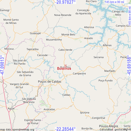
Botelhos GPS coordinates[2]
21° 37' 59.988" South, 46° 23' 42" West
| Map corner | latitude | longitude |
|---|---|---|
| Upper-left | -20.97827°, | -47.09813° |
| Center: | -21.63333°, | -46.395° |
| Lower-right: | -22.28544°, | -45.69188° |
| Map W x H: | 145.3×145.3 km | = 90.3×90.3mi |
| max Lat: | 2.81972° ⇑67.5% North |
| Botelhos: | -21.63333° |
| min Lat: | ⇓32.5% South -33.69111° |
| min Long | Botelhos | max Long |
| -72.89583° | -46.395° | -32.41083° |
| W 45.7%⇐ | ⇒54.3% E |
Elevation
Elevation of Botelhos is 977 m = 3205 ft, and this is 596.1 m = 1956 ft above average elevation for this country.
| Max E: |
1603 m = 5259 ft | 2.1% |
| Botelhos | 977 m 3205 ft | |
| Avg. | 380.9 m = 1250 ft | |
Min E: |
0 m = 0 ft | 97.9% |
See also: Brazil elevation on elevation.city.
Geographical zone
Botelhos is located in South Torrid zone (between Equator and Tropic of Capricorn). Distance of this Southern Tropic circle is 200.5 km =124.6 mi to South.| Distance of | km | miles | from Botelhos |
|---|---|---|---|
| Equator | 2405.4 | 1494.6 | to North |
| Tropic Capricorn | 200.5 | 124.6 | to South |
| Antarctic Circle | 4995.8 | 3104.2 | to South |
| South Pole | 7601.7 | 4723.5 | to South |


Nearby cities:
15 places around Botelhos: (largest is in red/bold)
• Alfenas
51.6 km =32.1 mi,  63°
63°
• Alterosa
50 km =31.1 mi,  31°
31°
• Andradas
51.6 km =32.1 mi,  200°
200°
• Areado
40 km =24.9 mi,  40°
40°
• Caconde
28.2 km =17.5 mi,  294°
294°
• Campestre
17.6 km =10.9 mi,  119°
119°
• Espírito Santo do Pinhal
61.3 km =38.1 mi,  208°
208°
• Guaranésia
56.2 km =34.9 mi,  311°
311°
• Guaxupé
49.1 km =30.5 mi,  317°
317°
• Machado
49.3 km =30.6 mi,  95°
95°
• Muzambinho
31.7 km =19.7 mi,  334°
334°
• Poços de Caldas
24.3 km =15.1 mi,  225°
225°
• São José do Rio Pardo
51.2 km =31.8 mi,  274°
274°
• São João da Boa Vista
55.9 km =34.7 mi, 228°
• Vargem Grande do Sul
56 km =34.8 mi,  246°
246°
Sources, notices
• [Note1] Compared only with cities in Brazil existing in our database
• [Src1] Map data: © OpenStreetMap contributors (CC-BY-SA)
• [Src2] Other city data from geonames.org with taken over terms of usage.
• [Src3] Geographical zone / Annual Mean Temperature by Robert A. Rohde @ Wikipedia
