Guaratuba geodata
Guaratuba (Paraná) is a populated place; located in Brazil in America/Sao_Paulo (GMT-3) time zone. With population of 18,906 people, there are 986 cities with bigger population in this country. Compared to other cities in Brazil, 89.4% of cities are located further ↑North; 68.5% of cities are located further →East and 98.3% of cities have higher elevation than Guaratuba. Note1


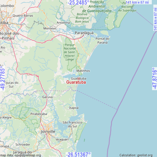
Guaratuba GPS coordinates[2]
25° 52' 58.008" South, 48° 34' 28.992" West
| Map corner | latitude | longitude |
|---|---|---|
| Upper-left | -25.2485°, | -49.27785° |
| Center: | -25.88278°, | -48.57472° |
| Lower-right: | -26.51367°, | -47.8716° |
| Map W x H: | 140.7×140.7 km | = 87.4×87.4mi |
| max Lat: | 2.81972° ⇑89.4% North |
| Guaratuba: | -25.88278° |
| min Lat: | ⇓10.6% South -33.69111° |
| min Long | Guaratuba | max Long |
| -72.89583° | -48.57472° | -32.41083° |
| W 31.5%⇐ | ⇒68.5% E |
Elevation
Elevation of Guaratuba is 6 m = 20 ft, and this is 374.9 m = 1230 ft below average elevation for this country.
| Max E: |
1603 m = 5259 ft | 98.3% |
| Avg. | 380.9 m = 1250 ft | |
| Guaratuba | 6 m = 20 ft | |
Min E: |
0 m = 0 ft | 1.7% |
See also: Brazil elevation on elevation.city.
Geographical zone
Guaratuba is located in South temperate zone (between Tropic of Capricorn and the Antarctic Circle). Distance of this Southern Tropic circle is 272 km =169 mi to North.| Distance of | km | miles | from Guaratuba |
|---|---|---|---|
| Equator | 2877.9 | 1788.2 | to North |
| Tropic Capricorn | 272 | 169 | to North |
| Antarctic Circle | 4523.3 | 2810.6 | to South |
| South Pole | 7129.2 | 4429.9 | to South |


Nearby cities:
15 places around Guaratuba: (largest is in red/bold)
• Antonina
52.3 km =32.5 mi,  344°
344°
• Barra Velha
84 km =52.2 mi,  187°
187°
• Campina Grande do Sul
80.3 km =49.9 mi,  323°
323°
• Curitiba
86.4 km =53.7 mi,  305°
305°
• Guaramirim
78.3 km =48.7 mi,  213°
213°
• Jaraguá do Sul
83.1 km =51.6 mi,  216°
216°
• Joinville
54.1 km =33.6 mi, 209°
• Paranaguá
41.1 km =25.5 mi,  6°
6°
• Pinhais
78.8 km =49 mi, 308°
• Piraquara
69.6 km =43.2 mi, 314°
• Pontal do Paraná
24.1 km =15 mi,  15°
15°
• Quatro Barras
76.4 km =47.5 mi, 318°
• Schroeder
77.1 km =47.9 mi, 220°
• São Francisco do Sul
40.6 km =25.2 mi, 188°
• São José dos Pinhais
74.6 km =46.4 mi,  301°
301°
Sources, notices
• [Note1] Compared only with cities in Brazil existing in our database
• [Src1] Map data: © OpenStreetMap contributors (CC-BY-SA)
• [Src2] Other city data from geonames.org with taken over terms of usage.
• [Src3] Geographical zone / Annual Mean Temperature by Robert A. Rohde @ Wikipedia
