Jaraguá do Sul geodata
Jaraguá do Sul (Santa Catarina) is a populated place; located in Brazil in America/Sao_Paulo (GMT-3) time zone. With population of 130,130 people, there are 172 cities with bigger population in this country. Compared to other cities in Brazil, 90.5% of cities are located further ↑North; 71.9% of cities are located further →East and 86.2% of cities have higher elevation than Jaraguá do Sul. Note1


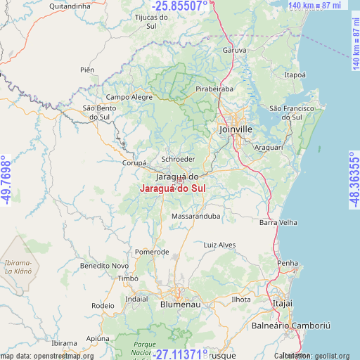
Jaraguá do Sul GPS coordinates[2]
26° 29' 9.996" South, 49° 4' 0.012" West
| Map corner | latitude | longitude |
|---|---|---|
| Upper-left | -25.85507°, | -49.7698° |
| Center: | -26.48611°, | -49.06667° |
| Lower-right: | -27.11371°, | -48.36355° |
| Map W x H: | 139.9×139.9 km | = 86.9×86.9mi |
| max Lat: | 2.81972° ⇑90.5% North |
| Jaraguá do Sul: | -26.48611° |
| min Lat: | ⇓9.5% South -33.69111° |
| min Long | Jaraguá do Sul | max Long |
| -72.89583° | -49.06667° | -32.41083° |
| W 28.1%⇐ | ⇒71.9% E |
Elevation
Elevation of Jaraguá do Sul is 27 m = 89 ft, and this is 353.9 m = 1161 ft below average elevation for this country.
| Max E: |
1603 m = 5259 ft | 86.2% |
| Avg. | 380.9 m = 1250 ft | |
| Jaraguá do Sul | 27 m = 89 ft | |
Min E: |
0 m = 0 ft | 13.8% |
See also: Jaraguá do Sul elevation on elevation.city.
Geographical zone
Jaraguá do Sul is located in South temperate zone (between Tropic of Capricorn and the Antarctic Circle). Distance of this Southern Tropic circle is 339.1 km =210.7 mi to North.| Distance of | km | miles | from Jaraguá do Sul |
|---|---|---|---|
| Equator | 2945 | 1829.9 | to North |
| Tropic Capricorn | 339.1 | 210.7 | to North |
| Antarctic Circle | 4456.2 | 2769 | to South |
| South Pole | 7062.1 | 4388.2 | to South |


Nearby cities:
15 places around Jaraguá do Sul: (largest is in red/bold)
• Barra Velha
41.3 km =25.7 mi,  113°
113°
• Blumenau
48.2 km =30 mi,  179°
179°
• Corupá
18.8 km =11.7 mi,  291°
291°
• Gaspar
50.7 km =31.5 mi,  167°
167°
• Guaramirim
6.5 km =4 mi,  77°
77°
• Indaial
48.6 km =30.2 mi,  199°
199°
• Joinville
29.9 km =18.6 mi,  47°
47°
• Penha
52.4 km =32.6 mi,  126°
126°
• Pomerode
30.3 km =18.8 mi, 201°
• Residencia Moacir PU5BHV
55.7 km =34.6 mi,  212°
212°
• Rio Negrinho
51.8 km =32.2 mi,  299°
299°
• Schroeder
8.2 km =5.1 mi,  355°
355°
• São Bento do Sul
40.7 km =25.3 mi,  310°
310°
• São Francisco do Sul
50.5 km =31.4 mi,  57°
57°
• Timbó
42.7 km =26.5 mi, 208°
Sources, notices
• [Note1] Compared only with cities in Brazil existing in our database
• [Src1] Map data: © OpenStreetMap contributors (CC-BY-SA)
• [Src2] Other city data from geonames.org with taken over terms of usage.
• [Src3] Geographical zone / Annual Mean Temperature by Robert A. Rohde @ Wikipedia
