Barra Velha geodata
Barra Velha (Santa Catarina) is a populated place; located in Brazil in America/Sao_Paulo (GMT-3) time zone. With population of 17,665 people, there are 1056 cities with bigger population in this country. Compared to other cities in Brazil, 90.6% of cities are located further ↑North; 69.4% of cities are located further →East and 91.7% of cities have higher elevation than Barra Velha. Note1


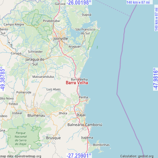
Barra Velha GPS coordinates[2]
26° 37' 55.992" South, 48° 41' 4.992" West
| Map corner | latitude | longitude |
|---|---|---|
| Upper-left | -26.00198°, | -49.38785° |
| Center: | -26.63222°, | -48.68472° |
| Lower-right: | -27.25901°, | -47.9816° |
| Map W x H: | 139.8×139.8 km | = 86.9×86.9mi |
| max Lat: | 2.81972° ⇑90.6% North |
| Barra Velha: | -26.63222° |
| min Lat: | ⇓9.4% South -33.69111° |
| min Long | Barra Velha | max Long |
| -72.89583° | -48.68472° | -32.41083° |
| W 30.6%⇐ | ⇒69.4% E |
Elevation
Elevation of Barra Velha is 14 m = 46 ft, and this is 366.9 m = 1204 ft below average elevation for this country.
| Max E: |
1603 m = 5259 ft | 91.7% |
| Avg. | 380.9 m = 1250 ft | |
| Barra Velha | 14 m = 46 ft | |
Min E: |
0 m = 0 ft | 8.3% |
See also: Brazil elevation on elevation.city.
Geographical zone
Barra Velha is located in South temperate zone (between Tropic of Capricorn and the Antarctic Circle). Distance of this Southern Tropic circle is 355.3 km =220.8 mi to North.| Distance of | km | miles | from Barra Velha |
|---|---|---|---|
| Equator | 2961.2 | 1840 | to North |
| Tropic Capricorn | 355.3 | 220.8 | to North |
| Antarctic Circle | 4439.9 | 2758.8 | to South |
| South Pole | 7045.8 | 4378.1 | to South |


Nearby cities:
15 places around Barra Velha: (largest is in red/bold)
• Balneário Camboriú
40.2 km =25 mi,  172°
172°
• Blumenau
49.5 km =30.8 mi,  229°
229°
• Brusque
56.5 km =35.1 mi,  203°
203°
• Gaspar
43 km =26.7 mi,  219°
219°
• Guaramirim
36.2 km =22.5 mi,  299°
299°
• Itajaí
30.7 km =19.1 mi,  175°
175°
• Itapema
51.4 km =31.9 mi, 171°
• Jaraguá do Sul
41.3 km =25.7 mi,  293°
293°
• Joinville
39.8 km =24.7 mi,  336°
336°
• Navegantes
29.8 km =18.5 mi, 174°
• Penha
15.7 km =9.8 mi, 165°
• Pomerode
50.4 km =31.3 mi,  256°
256°
• Porto Belo
59.9 km =37.2 mi, 167°
• Schroeder
45.7 km =28.4 mi, 302°
• São Francisco do Sul
43.5 km =27 mi,  6°
6°
Sources, notices
• [Note1] Compared only with cities in Brazil existing in our database
• [Src1] Map data: © OpenStreetMap contributors (CC-BY-SA)
• [Src2] Other city data from geonames.org with taken over terms of usage.
• [Src3] Geographical zone / Annual Mean Temperature by Robert A. Rohde @ Wikipedia
