Joinville geodata
Joinville (Santa Catarina) is a populated place; located in Brazil in America/Sao_Paulo (GMT-3) time zone. With population of 461,304 people, there are 39 cities with bigger population in this country. Compared to other cities in Brazil, 90.2% of cities are located further ↑North; 70.5% of cities are located further →East and 95.4% of cities have higher elevation than Joinville. Note1


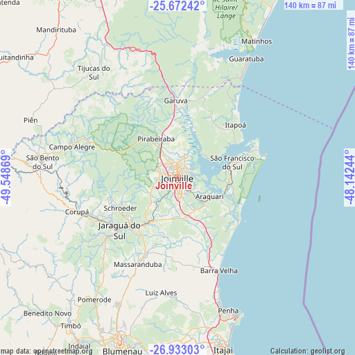
Joinville GPS coordinates[2]
26° 18' 15.984" South, 48° 50' 44.016" West
| Map corner | latitude | longitude |
|---|---|---|
| Upper-left | -25.67242°, | -49.54869° |
| Center: | -26.30444°, | -48.84556° |
| Lower-right: | -26.93303°, | -48.14244° |
| Map W x H: | 140.2×140.2 km | = 87.1×87.1mi |
| max Lat: | 2.81972° ⇑90.2% North |
| Joinville: | -26.30444° |
| min Lat: | ⇓9.8% South -33.69111° |
| min Long | Joinville | max Long |
| -72.89583° | -48.84556° | -32.41083° |
| W 29.5%⇐ | ⇒70.5% E |
Elevation
Elevation of Joinville is 9 m = 30 ft, and this is 371.9 m = 1220 ft below average elevation for this country.
| Max E: |
1603 m = 5259 ft | 95.4% |
| Avg. | 380.9 m = 1250 ft | |
| Joinville | 9 m = 30 ft | |
Min E: |
0 m = 0 ft | 4.6% |
See also: Joinville elevation on elevation.city.
Geographical zone
Joinville is located in South temperate zone (between Tropic of Capricorn and the Antarctic Circle). Distance of this Southern Tropic circle is 318.9 km =198.2 mi to North.| Distance of | km | miles | from Joinville |
|---|---|---|---|
| Equator | 2924.8 | 1817.4 | to North |
| Tropic Capricorn | 318.9 | 198.2 | to North |
| Antarctic Circle | 4476.4 | 2781.5 | to South |
| South Pole | 7082.3 | 4400.7 | to South |


Nearby cities:
15 places around Joinville: (largest is in red/bold)
• Barra Velha
39.8 km =24.7 mi,  156°
156°
• Corupá
41.8 km =26 mi,  251°
251°
• Gaspar
70.6 km =43.9 mi,  189°
189°
• Guaramirim
24.4 km =15.2 mi,  219°
219°
• Guaratuba
54.1 km =33.6 mi,  29°
29°
• Itajaí
69.5 km =43.2 mi, 164°
• Jaraguá do Sul
29.9 km =18.6 mi,  227°
227°
• Navegantes
68.8 km =42.8 mi, 163°
• Penha
55.4 km =34.4 mi, 158°
• Pomerode
58.6 km =36.4 mi,  214°
214°
• Rio Negrinho
67.3 km =41.8 mi,  274°
274°
• Schroeder
25.7 km =16 mi,  242°
242°
• São Bento do Sul
53.5 km =33.2 mi,  276°
276°
• São Francisco do Sul
21.8 km =13.5 mi,  71°
71°
• Timbó
71.6 km =44.5 mi, 216°
Sources, notices
• [Note1] Compared only with cities in Brazil existing in our database
• [Src1] Map data: © OpenStreetMap contributors (CC-BY-SA)
• [Src2] Other city data from geonames.org with taken over terms of usage.
• [Src3] Geographical zone / Annual Mean Temperature by Robert A. Rohde @ Wikipedia
