Schroeder geodata
Schroeder (Santa Catarina) is a populated place; located in Brazil in America/Sao_Paulo (GMT-3) time zone. With population of 15,505 people, there are 1191 cities with bigger population in this country. Compared to other cities in Brazil, 90.3% of cities are located further ↑North; 72% of cities are located further →East and 80.1% of cities have higher elevation than Schroeder. Note1


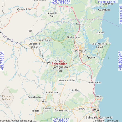
Schroeder GPS coordinates[2]
26° 24' 45" South, 49° 4' 23.016" West
| Map corner | latitude | longitude |
|---|---|---|
| Upper-left | -25.78106°, | -49.77619° |
| Center: | -26.4125°, | -49.07306° |
| Lower-right: | -27.0405°, | -48.36994° |
| Map W x H: | 140×140 km | = 87×87mi |
| max Lat: | 2.81972° ⇑90.3% North |
| Schroeder: | -26.4125° |
| min Lat: | ⇓9.7% South -33.69111° |
| min Long | Schroeder | max Long |
| -72.89583° | -49.07306° | -32.41083° |
| W 28%⇐ | ⇒72% E |
Elevation
Elevation of Schroeder is 46 m = 151 ft, and this is 334.9 m = 1099 ft below average elevation for this country.
| Max E: |
1603 m = 5259 ft | 80.1% |
| Avg. | 380.9 m = 1250 ft | |
| Schroeder | 46 m = 151 ft | |
Min E: |
0 m = 0 ft | 19.9% |
See also: Brazil elevation on elevation.city.
Geographical zone
Schroeder is located in South temperate zone (between Tropic of Capricorn and the Antarctic Circle). Distance of this Southern Tropic circle is 330.9 km =205.6 mi to North.| Distance of | km | miles | from Schroeder |
|---|---|---|---|
| Equator | 2936.8 | 1824.8 | to North |
| Tropic Capricorn | 330.9 | 205.6 | to North |
| Antarctic Circle | 4464.4 | 2774 | to South |
| South Pole | 7070.3 | 4393.3 | to South |


Nearby cities:
15 places around Schroeder: (largest is in red/bold)
• Barra Velha
45.7 km =28.4 mi,  122°
122°
• Blumenau
56.4 km =35 mi,  179°
179°
• Corupá
17 km =10.6 mi,  265°
265°
• Gaspar
58.8 km =36.5 mi,  168°
168°
• Guaramirim
9.7 km =6 mi,  133°
133°
• Indaial
56.2 km =34.9 mi,  196°
196°
• Jaraguá do Sul
8.2 km =5.1 mi, 175°
• Joinville
25.7 km =16 mi,  62°
62°
• Penha
58.1 km =36.1 mi, 133°
• Pomerode
37.9 km =23.5 mi, 195°
• Residencia Moacir PU5BHV
62.5 km =38.8 mi,  207°
207°
• Rio Negrinho
47.7 km =29.6 mi,  291°
291°
• São Bento do Sul
35.4 km =22 mi,  300°
300°
• São Francisco do Sul
47.3 km =29.4 mi,  66°
66°
• Timbó
49.8 km =30.9 mi, 203°
Sources, notices
• [Note1] Compared only with cities in Brazil existing in our database
• [Src1] Map data: © OpenStreetMap contributors (CC-BY-SA)
• [Src2] Other city data from geonames.org with taken over terms of usage.
• [Src3] Geographical zone / Annual Mean Temperature by Robert A. Rohde @ Wikipedia
