Serra geodata
Serra (Espírito Santo) is a populated place; located in Brazil in America/Sao_Paulo (GMT-3) time zone. With population of 394,153 people, there are 47 cities with bigger population in this country. Compared to other cities in Brazil, 57.9% of cities are located further ↑North; 73.9% of cities are located further ←West and 77.9% of cities have higher elevation than Serra. Note1


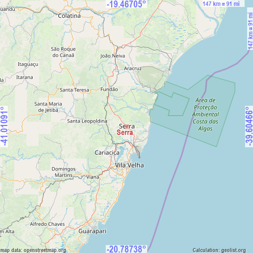
Serra GPS coordinates[2]
20° 7' 42.996" South, 40° 18' 28.008" West
| Map corner | latitude | longitude |
|---|---|---|
| Upper-left | -19.46705°, | -41.01091° |
| Center: | -20.12861°, | -40.30778° |
| Lower-right: | -20.78738°, | -39.60466° |
| Map W x H: | 146.8×146.8 km | = 91.2×91.2mi |
| max Lat: | 2.81972° ⇑57.9% North |
| Serra: | -20.12861° |
| min Lat: | ⇓42.1% South -33.69111° |
| min Long | Serra | max Long |
| -72.89583° | -40.30778° | -32.41083° |
| W 73.9%⇐ | ⇒26.1% E |
Elevation
Elevation of Serra is 57 m = 187 ft, and this is 323.9 m = 1063 ft below average elevation for this country.
| Max E: |
1603 m = 5259 ft | 77.9% |
| Avg. | 380.9 m = 1250 ft | |
| Serra | 57 m = 187 ft | |
Min E: |
0 m = 0 ft | 22.1% |
See also: Serra elevation on elevation.city.
Geographical zone
Serra is located in South Torrid zone (between Equator and Tropic of Capricorn). Distance of this Southern Tropic circle is 367.8 km =228.5 mi to South.| Distance of | km | miles | from Serra |
|---|---|---|---|
| Equator | 2238.1 | 1390.7 | to North |
| Tropic Capricorn | 367.8 | 228.5 | to South |
| Antarctic Circle | 5163.1 | 3208.2 | to South |
| South Pole | 7769 | 4827.4 | to South |


Nearby cities:
15 places around Serra: (largest is in red/bold)
• Aracruz
34.5 km =21.4 mi,  5°
5°
• Domingos Martins
45 km =28 mi,  234°
234°
• Fundão
23.9 km =14.9 mi,  334°
334°
• Guarapari
63.7 km =39.6 mi,  198°
198°
• Ibiraçu
33.6 km =20.9 mi,  348°
348°
• Itarana
65.7 km =40.8 mi,  295°
295°
• Jetibá
40.8 km =25.4 mi,  287°
287°
• João Neiva
42.1 km =26.2 mi, 348°
• Marechal Floriano
50.3 km =31.3 mi, 231°
• Santa Leopoldina
23.4 km =14.5 mi,  277°
277°
• Santa Maria de Jetibá
46.9 km =29.1 mi, 283°
• Santa Teresa
37.3 km =23.2 mi,  305°
305°
• Viana
35.1 km =21.8 mi,  214°
214°
• Vila Velha
22.4 km =13.9 mi,  175°
175°
• Vitória
21.4 km =13.3 mi,  188°
188°
Sources, notices
• [Note1] Compared only with cities in Brazil existing in our database
• [Src1] Map data: © OpenStreetMap contributors (CC-BY-SA)
• [Src2] Other city data from geonames.org with taken over terms of usage.
• [Src3] Geographical zone / Annual Mean Temperature by Robert A. Rohde @ Wikipedia
