Guapiaçu geodata
Guapiaçu (São Paulo) is a populated place; located in Brazil in America/Sao_Paulo (GMT-3) time zone. With population of 14,065 people, there are 1284 cities with bigger population in this country. Compared to other cities in Brazil, 61.9% of cities are located further ↑North; 73.2% of cities are located further →East and 62.9% of cities have lower elevation than Guapiaçu. Note1


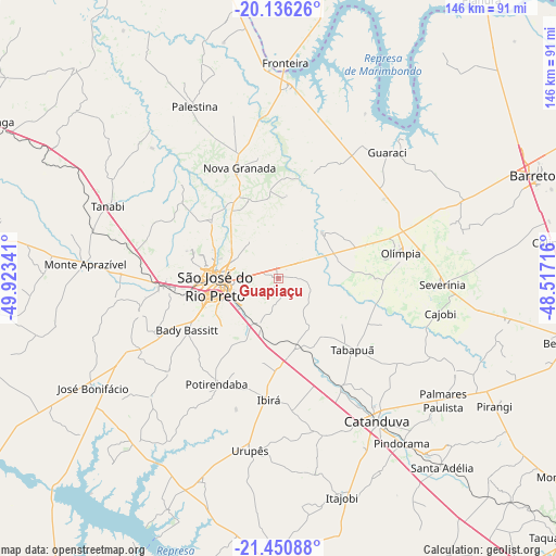
Guapiaçu GPS coordinates[2]
20° 47' 42" South, 49° 13' 13.008" West
| Map corner | latitude | longitude |
|---|---|---|
| Upper-left | -20.13626°, | -49.92341° |
| Center: | -20.795°, | -49.22028° |
| Lower-right: | -21.45088°, | -48.51716° |
| Map W x H: | 146.2×146.2 km | = 90.8×90.8mi |
| max Lat: | 2.81972° ⇑61.9% North |
| Guapiaçu: | -20.795° |
| min Lat: | ⇓38.1% South -33.69111° |
| min Long | Guapiaçu | max Long |
| -72.89583° | -49.22028° | -32.41083° |
| W 26.8%⇐ | ⇒73.2% E |
Elevation
Elevation of Guapiaçu is 508 m = 1667 ft, and this is 127.1 m = 417 ft above average elevation for this country.
| Max E: |
1603 m = 5259 ft | 37.1% |
| Guapiaçu | 508 m 1667 ft | |
| Avg. | 380.9 m = 1250 ft | |
Min E: |
0 m = 0 ft | 62.9% |
See also: Brazil elevation on elevation.city.
Geographical zone
Guapiaçu is located in South Torrid zone (between Equator and Tropic of Capricorn). Distance of this Southern Tropic circle is 293.7 km =182.5 mi to South.| Distance of | km | miles | from Guapiaçu |
|---|---|---|---|
| Equator | 2312.2 | 1436.7 | to North |
| Tropic Capricorn | 293.7 | 182.5 | to South |
| Antarctic Circle | 5089 | 3162.2 | to South |
| South Pole | 7694.9 | 4781.4 | to South |


Nearby cities:
15 places around Guapiaçu: (largest is in red/bold)
• Bady Bassitt
27.1 km =16.8 mi,  239°
239°
• Catanduva
46 km =28.6 mi,  146°
146°
• Itajobi
60.7 km =37.7 mi,  163°
163°
• José Bonifácio
56.4 km =35 mi, 239°
• Monte Aprazível
51.4 km =31.9 mi,  272°
272°
• Monte Azul Paulista
61.4 km =38.2 mi,  101°
101°
• Nova Granada
30.6 km =19 mi,  341°
341°
• Olímpia
32.4 km =20.1 mi,  78°
78°
• Paraíso
52.5 km =32.6 mi,  117°
117°
• Pindorama
54.3 km =33.7 mi,  143°
143°
• Santa Adélia
65.9 km =40.9 mi, 139°
• Severínia
43.4 km =27 mi,  92°
92°
• São José do Rio Preto
16.8 km =10.4 mi,  260°
260°
• Tanabi
48.4 km =30.1 mi,  292°
292°
• Urupês
45.8 km =28.5 mi,  189°
189°
Sources, notices
• [Note1] Compared only with cities in Brazil existing in our database
• [Src1] Map data: © OpenStreetMap contributors (CC-BY-SA)
• [Src2] Other city data from geonames.org with taken over terms of usage.
• [Src3] Geographical zone / Annual Mean Temperature by Robert A. Rohde @ Wikipedia
