Tanabi geodata
Tanabi (São Paulo) is a populated place; located in Brazil in America/Sao_Paulo (GMT-3) time zone. With population of 18,227 people, there are 1028 cities with bigger population in this country. Compared to other cities in Brazil, 60.6% of cities are located further ↑North; 76.5% of cities are located further →East and 64.4% of cities have lower elevation than Tanabi. Note1


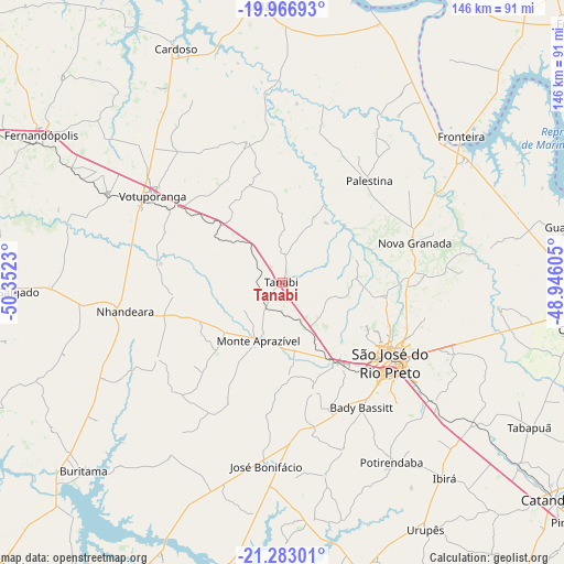
Tanabi GPS coordinates[2]
20° 37' 35.004" South, 49° 38' 57.012" West
| Map corner | latitude | longitude |
|---|---|---|
| Upper-left | -19.96693°, | -50.3523° |
| Center: | -20.62639°, | -49.64917° |
| Lower-right: | -21.28301°, | -48.94605° |
| Map W x H: | 146.3×146.3 km | = 90.9×90.9mi |
| max Lat: | 2.81972° ⇑60.6% North |
| Tanabi: | -20.62639° |
| min Lat: | ⇓39.4% South -33.69111° |
| min Long | Tanabi | max Long |
| -72.89583° | -49.64917° | -32.41083° |
| W 23.5%⇐ | ⇒76.5% E |
Elevation
Elevation of Tanabi is 519 m = 1703 ft, and this is 138.1 m = 453 ft above average elevation for this country.
| Max E: |
1603 m = 5259 ft | 35.6% |
| Tanabi | 519 m 1703 ft | |
| Avg. | 380.9 m = 1250 ft | |
Min E: |
0 m = 0 ft | 64.4% |
See also: Brazil elevation on elevation.city.
Geographical zone
Tanabi is located in South Torrid zone (between Equator and Tropic of Capricorn). Distance of this Southern Tropic circle is 312.5 km =194.2 mi to South.| Distance of | km | miles | from Tanabi |
|---|---|---|---|
| Equator | 2293.4 | 1425.1 | to North |
| Tropic Capricorn | 312.5 | 194.2 | to South |
| Antarctic Circle | 5107.7 | 3173.8 | to South |
| South Pole | 7713.6 | 4793 | to South |


Nearby cities:
15 places around Tanabi: (largest is in red/bold)
• Bady Bassitt
38.7 km =24 mi,  146°
146°
• Buritama
71.2 km =44.2 mi,  226°
226°
• Cardoso
66.5 km =41.3 mi,  335°
335°
• Fernandópolis
72.9 km =45.3 mi,  301°
301°
• General Salgado
74.1 km =46 mi,  268°
268°
• Guapiaçu
48.4 km =30.1 mi,  112°
112°
• José Bonifácio
47.6 km =29.6 mi,  184°
184°
• Monte Aprazível
17.6 km =10.9 mi,  202°
202°
• Nhandeara
41.3 km =25.7 mi,  260°
260°
• Nova Granada
36.4 km =22.6 mi,  73°
73°
• Olímpia
77.4 km =48.1 mi,  99°
99°
• Riolândia
71.9 km =44.7 mi,  357°
357°
• São José do Rio Preto
35.3 km =21.9 mi,  127°
127°
• Urupês
74 km =46 mi, 149°
• Votuporanga
40.6 km =25.2 mi, 303°
Sources, notices
• [Note1] Compared only with cities in Brazil existing in our database
• [Src1] Map data: © OpenStreetMap contributors (CC-BY-SA)
• [Src2] Other city data from geonames.org with taken over terms of usage.
• [Src3] Geographical zone / Annual Mean Temperature by Robert A. Rohde @ Wikipedia
