Catanduva geodata
Catanduva (São Paulo) is a populated place; located in Brazil in America/Sao_Paulo (GMT-3) time zone. With population of 109,612 people, there are 207 cities with bigger population in this country. Compared to other cities in Brazil, 64.1% of cities are located further ↑North; 71.3% of cities are located further →East and 64.1% of cities have lower elevation than Catanduva. Note1


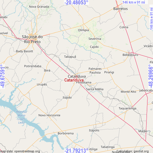
Catanduva GPS coordinates[2]
21° 8' 16.008" South, 48° 58' 22.008" West
| Map corner | latitude | longitude |
|---|---|---|
| Upper-left | -20.48053°, | -49.67591° |
| Center: | -21.13778°, | -48.97278° |
| Lower-right: | -21.79213°, | -48.26966° |
| Map W x H: | 145.8×145.8 km | = 90.6×90.6mi |
| max Lat: | 2.81972° ⇑64.1% North |
| Catanduva: | -21.13778° |
| min Lat: | ⇓35.9% South -33.69111° |
| min Long | Catanduva | max Long |
| -72.89583° | -48.97278° | -32.41083° |
| W 28.7%⇐ | ⇒71.3% E |
Elevation
Elevation of Catanduva is 517 m = 1696 ft, and this is 136.1 m = 447 ft above average elevation for this country.
| Max E: |
1603 m = 5259 ft | 35.9% |
| Catanduva | 517 m 1696 ft | |
| Avg. | 380.9 m = 1250 ft | |
Min E: |
0 m = 0 ft | 64.1% |
See also: Catanduva elevation on elevation.city.
Geographical zone
Catanduva is located in South Torrid zone (between Equator and Tropic of Capricorn). Distance of this Southern Tropic circle is 255.6 km =158.8 mi to South.| Distance of | km | miles | from Catanduva |
|---|---|---|---|
| Equator | 2350.3 | 1460.4 | to North |
| Tropic Capricorn | 255.6 | 158.8 | to South |
| Antarctic Circle | 5050.9 | 3138.5 | to South |
| South Pole | 7656.8 | 4757.7 | to South |


Nearby cities:
15 places around Catanduva: (largest is in red/bold)
• Bady Bassitt
54.8 km =34.1 mi,  296°
296°
• Borborema
54.6 km =33.9 mi,  191°
191°
• Guapiaçu
46 km =28.6 mi,  326°
326°
• Itajobi
21.8 km =13.5 mi,  202°
202°
• Itápolis
53.5 km =33.2 mi,  161°
161°
• Monte Alto
51.3 km =31.9 mi,  105°
105°
• Monte Azul Paulista
42.9 km =26.7 mi,  53°
53°
• Novo Horizonte
44.8 km =27.8 mi,  214°
214°
• Olímpia
44.9 km =27.9 mi,  7°
7°
• Paraíso
24.7 km =15.3 mi,  56°
56°
• Pindorama
8.6 km =5.3 mi,  128°
128°
• Santa Adélia
21 km =13 mi,  123°
123°
• Severínia
40.6 km =25.2 mi,  25°
25°
• São José do Rio Preto
55.1 km =34.2 mi,  309°
309°
• Urupês
33.6 km =20.9 mi,  257°
257°
Sources, notices
• [Note1] Compared only with cities in Brazil existing in our database
• [Src1] Map data: © OpenStreetMap contributors (CC-BY-SA)
• [Src2] Other city data from geonames.org with taken over terms of usage.
• [Src3] Geographical zone / Annual Mean Temperature by Robert A. Rohde @ Wikipedia
