Nova Granada geodata
Nova Granada (São Paulo) is a populated place; located in Brazil in America/Sao_Paulo (GMT-3) time zone. With population of 15,715 people, there are 1174 cities with bigger population in this country. Compared to other cities in Brazil, 60.3% of cities are located further ↑North; 74.1% of cities are located further →East and 64.5% of cities have lower elevation than Nova Granada. Note1


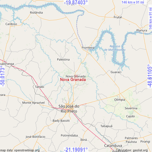
Nova Granada GPS coordinates[2]
20° 32' 2.004" South, 49° 18' 51.012" West
| Map corner | latitude | longitude |
|---|---|---|
| Upper-left | -19.87403°, | -50.0173° |
| Center: | -20.53389°, | -49.31417° |
| Lower-right: | -21.19091°, | -48.61105° |
| Map W x H: | 146.4×146.4 km | = 91×91mi |
| max Lat: | 2.81972° ⇑60.3% North |
| Nova Granada: | -20.53389° |
| min Lat: | ⇓39.7% South -33.69111° |
| min Long | Nova Granada | max Long |
| -72.89583° | -49.31417° | -32.41083° |
| W 25.9%⇐ | ⇒74.1% E |
Elevation
Elevation of Nova Granada is 520 m = 1706 ft, and this is 139.1 m = 456 ft above average elevation for this country.
| Max E: |
1603 m = 5259 ft | 35.5% |
| Nova Granada | 520 m 1706 ft | |
| Avg. | 380.9 m = 1250 ft | |
Min E: |
0 m = 0 ft | 64.5% |
See also: Brazil elevation on elevation.city.
Geographical zone
Nova Granada is located in South Torrid zone (between Equator and Tropic of Capricorn). Distance of this Southern Tropic circle is 322.8 km =200.6 mi to South.| Distance of | km | miles | from Nova Granada |
|---|---|---|---|
| Equator | 2283.2 | 1418.7 | to North |
| Tropic Capricorn | 322.8 | 200.6 | to South |
| Antarctic Circle | 5118 | 3180.2 | to South |
| South Pole | 7723.9 | 4799.4 | to South |


Nearby cities:
15 places around Nova Granada: (largest is in red/bold)
• Bady Bassitt
44.8 km =27.8 mi,  197°
197°
• Catanduva
75.9 km =47.2 mi,  152°
152°
• Frutal
68.7 km =42.7 mi,  34°
34°
• Guapiaçu
30.6 km =19 mi,  161°
161°
• José Bonifácio
69.6 km =43.2 mi,  213°
213°
• Monte Aprazível
49.4 km =30.7 mi,  237°
237°
• Nhandeara
77.6 km =48.2 mi,  257°
257°
• Olímpia
47.3 km =29.4 mi,  118°
118°
• Paraíso
77.7 km =48.3 mi,  133°
133°
• Riolândia
72.5 km =45 mi,  328°
328°
• Severínia
61.4 km =38.2 mi, 119°
• São José do Rio Preto
32.5 km =20.2 mi,  192°
192°
• Tanabi
36.4 km =22.6 mi,  253°
253°
• Urupês
74.3 km =46.2 mi,  178°
178°
• Votuporanga
69.7 km =43.3 mi,  280°
280°
Sources, notices
• [Note1] Compared only with cities in Brazil existing in our database
• [Src1] Map data: © OpenStreetMap contributors (CC-BY-SA)
• [Src2] Other city data from geonames.org with taken over terms of usage.
• [Src3] Geographical zone / Annual Mean Temperature by Robert A. Rohde @ Wikipedia
