Residencia Moacir PU5BHV geodata
Residencia Moacir PU5BHV (Santa Catarina) is a populated place; located in Brazil in America/Sao_Paulo (GMT-3) time zone. With population of 10,000 people, there are 1652 cities with bigger population in this country. Compared to other cities in Brazil, 91% of cities are located further ↑North; 74.5% of cities are located further →East and 72.8% of cities have higher elevation than Residencia Moacir PU5BHV. Note1
Current local time in Residencia Moacir PU5BHV:
10:25 AM, ThursdayDifference from your time zone: hours


Residencia Moacir PU5BHV GPS coordinates[2]
26° 54' 34.812" South, 49° 21' 55.692" West
| Map corner | latitude | longitude |
|---|---|---|
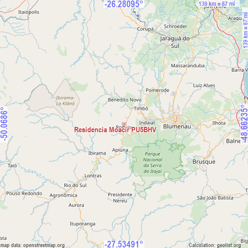
| Upper-left | -26.28095°, | -50.0686° |
| Center: | -26.90967°, | -49.36547° |
| Lower-right: | -27.53491°, | -48.66235° |
| Map W x H: | 139.4×139.4 km | = 86.6×86.6mi |
| max Lat: | 2.81972° ⇑91% North |
| Residencia Moacir PU5BHV: | -26.90967° |
| min Lat: | ⇓9% South -33.69111° |
| min Long | Residencia Moac | max Long |
| -72.89583° | -49.36547° | -32.41083° |
| W 25.5%⇐ | ⇒74.5% E |
Elevation
Elevation of Residencia Moacir PU5BHV is 96 m = 315 ft, and this is 284.9 m = 935 ft below average elevation for this country.
| Max E: |
1603 m = 5259 ft | 72.8% |
| Avg. | 380.9 m = 1250 ft | |
| Residencia Moacir PU5BHV | 96 m = 315 ft | |
Min E: |
0 m = 0 ft | 27.2% |
See also: Brazil elevation on elevation.city.
Geographical zone
Residencia Moacir PU5BHV is located in South temperate zone (between Tropic of Capricorn and the Antarctic Circle). Distance of this Southern Tropic circle is 386.2 km =240 mi to North.| Distance of | km | miles | from Residencia Moacir PU5BHV |
|---|---|---|---|
| Equator | 2992.1 | 1859.2 | to North |
| Tropic Capricorn | 386.2 | 240 | to North |
| Antarctic Circle | 4409.1 | 2739.7 | to South |
| South Pole | 7015 | 4358.9 | to South |


Nearby cities:
15 places around Residencia Moacir PU5BHV: (largest is in red/bold)
• Blumenau
29.7 km =18.5 mi,  92°
92°
• Brusque
49.5 km =30.8 mi,  115°
115°
• Corupá
55.2 km =34.3 mi,  12°
12°
• Gaspar
40.4 km =25.1 mi, 93°
• Guaramirim
60.5 km =37.6 mi,  36°
36°
• Ibirama
22.3 km =13.9 mi,  222°
222°
• Indaial
13.3 km =8.3 mi,  84°
84°
• Itajaí
69.8 km =43.4 mi, 89°
• Jaraguá do Sul
55.7 km =34.6 mi,  32°
32°
• Pomerode
26.5 km =16.5 mi, 44°
• Rio do Sul
43.6 km =27.1 mi, 219°
• Rodeio
1.5 km =0.9 mi,  183°
183°
• Schroeder
62.5 km =38.8 mi, 27°
• São João Batista
65.3 km =40.6 mi,  128°
128°
• Timbó
13.4 km =8.3 mi, 44°
Sources, notices
• [Note1] Compared only with cities in Brazil existing in our database
• [Src1] Map data: © OpenStreetMap contributors (CC-BY-SA)
• [Src2] Other city data from geonames.org with taken over terms of usage.
• [Src3] Geographical zone / Annual Mean Temperature by Robert A. Rohde @ Wikipedia
