Engenheiro Beltrão geodata
Engenheiro Beltrão (Paraná) is a populated place; located in Brazil in America/Sao_Paulo (GMT-3) time zone. With population of 14,954 people, there are 1215 cities with bigger population in this country. Compared to other cities in Brazil, 85.1% of cities are located further ↑North; 88.5% of cities are located further →East and 60.5% of cities have lower elevation than Engenheiro Beltrão. Note1


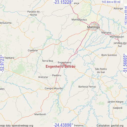
Engenheiro Beltrão GPS coordinates[2]
23° 47' 49.992" South, 52° 16' 9.012" West
| Map corner | latitude | longitude |
|---|---|---|
| Upper-left | -23.15229°, | -52.9723° |
| Center: | -23.79722°, | -52.26917° |
| Lower-right: | -24.43896°, | -51.56605° |
| Map W x H: | 143.1×143.1 km | = 88.9×88.9mi |
| max Lat: | 2.81972° ⇑85.1% North |
| Engenheiro Beltrão: | -23.79722° |
| min Lat: | ⇓14.9% South -33.69111° |
| min Long | Engenheiro Belt | max Long |
| -72.89583° | -52.26917° | -32.41083° |
| W 11.5%⇐ | ⇒88.5% E |
Elevation
Elevation of Engenheiro Beltrão is 479 m = 1572 ft, and this is 98.1 m = 322 ft above average elevation for this country.
| Max E: |
1603 m = 5259 ft | 39.5% |
| Engenheiro Beltrão | 479 m 1572 ft | |
| Avg. | 380.9 m = 1250 ft | |
Min E: |
0 m = 0 ft | 60.5% |
See also: Brazil elevation on elevation.city.
Geographical zone
Engenheiro Beltrão is located in South temperate zone (between Tropic of Capricorn and the Antarctic Circle). Distance of this Southern Tropic circle is 40.1 km =24.9 mi to North.| Distance of | km | miles | from Engenheiro Beltrão |
|---|---|---|---|
| Equator | 2646 | 1644.1 | to North |
| Tropic Capricorn | 40.1 | 24.9 | to North |
| Antarctic Circle | 4755.2 | 2954.7 | to South |
| South Pole | 7361.1 | 4574 | to South |


Nearby cities:
15 places around Engenheiro Beltrão: (largest is in red/bold)
• Alto Paraná
74.5 km =46.3 mi,  356°
356°
• Campo Mourão
29.5 km =18.3 mi,  202°
202°
• Cianorte
37.3 km =23.2 mi,  293°
293°
• Cruzeiro do Oeste
81.8 km =50.8 mi,  270°
270°
• Jandaia do Sul
67.3 km =41.8 mi,  71°
71°
• Mandaguari
67 km =41.6 mi, 65°
• Mandaguaçu
53.1 km =33 mi,  19°
19°
• Marialva
59.8 km =37.2 mi,  54°
54°
• Maringá
53.3 km =33.1 mi,  39°
39°
• Moreira Sales
80.6 km =50.1 mi,  248°
248°
• Paiçandu
44 km =27.3 mi,  30°
30°
• Peabiru
14.9 km =9.3 mi,  210°
210°
• Sarandi
56.3 km =35 mi, 45°
• Tapejara
61.9 km =38.5 mi,  276°
276°
• Terra Boa
18.1 km =11.2 mi, 280°
Sources, notices
• [Note1] Compared only with cities in Brazil existing in our database
• [Src1] Map data: © OpenStreetMap contributors (CC-BY-SA)
• [Src2] Other city data from geonames.org with taken over terms of usage.
• [Src3] Geographical zone / Annual Mean Temperature by Robert A. Rohde @ Wikipedia
