Jandaia do Sul geodata
Jandaia do Sul (Paraná) is a populated place; located in Brazil in America/Sao_Paulo (GMT-3) time zone. With population of 17,507 people, there are 1065 cities with bigger population in this country. Compared to other cities in Brazil, 83.7% of cities are located further ↑North; 86.2% of cities are located further →East and 90% of cities have lower elevation than Jandaia do Sul. Note1


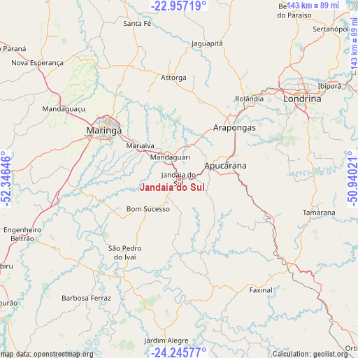
Jandaia do Sul GPS coordinates[2]
23° 36' 11.016" South, 51° 38' 35.988" West
| Map corner | latitude | longitude |
|---|---|---|
| Upper-left | -22.95719°, | -52.34646° |
| Center: | -23.60306°, | -51.64333° |
| Lower-right: | -24.24577°, | -50.94021° |
| Map W x H: | 143.3×143.3 km | = 89×89mi |
| max Lat: | 2.81972° ⇑83.7% North |
| Jandaia do Sul: | -23.60306° |
| min Lat: | ⇓16.3% South -33.69111° |
| min Long | Jandaia do Sul | max Long |
| -72.89583° | -51.64333° | -32.41083° |
| W 13.8%⇐ | ⇒86.2% E |
Elevation
Elevation of Jandaia do Sul is 814 m = 2671 ft, and this is 433.1 m = 1421 ft above average elevation for this country.
| Max E: |
1603 m = 5259 ft | 10% |
| Jandaia do Sul | 814 m 2671 ft | |
| Avg. | 380.9 m = 1250 ft | |
Min E: |
0 m = 0 ft | 90% |
See also: Brazil elevation on elevation.city.
Geographical zone
Jandaia do Sul is located in South temperate zone (between Tropic of Capricorn and the Antarctic Circle). Distance of this Southern Tropic circle is 18.5 km =11.5 mi to North.| Distance of | km | miles | from Jandaia do Sul |
|---|---|---|---|
| Equator | 2624.4 | 1630.7 | to North |
| Tropic Capricorn | 18.5 | 11.5 | to North |
| Antarctic Circle | 4776.8 | 2968.2 | to South |
| South Pole | 7382.6 | 4587.3 | to South |


Nearby cities:
15 places around Jandaia do Sul: (largest is in red/bold)
• Apucarana
19.5 km =12.1 mi,  72°
72°
• Arapongas
30.2 km =18.8 mi,  47°
47°
• Astorga
41.3 km =25.7 mi,  356°
356°
• Cambé
52.1 km =32.4 mi, 45°
• Engenheiro Beltrão
67.3 km =41.8 mi,  251°
251°
• Faxinal
55.1 km =34.2 mi,  143°
143°
• Ibiporã
71.2 km =44.2 mi,  58°
58°
• Londrina
58.8 km =36.5 mi, 56°
• Mandaguari
6.8 km =4.2 mi,  335°
335°
• Mandaguaçu
54.2 km =33.7 mi,  301°
301°
• Marialva
20 km =12.4 mi,  310°
310°
• Maringá
36 km =22.4 mi, 303°
• Paiçandu
44.4 km =27.6 mi,  291°
291°
• Rolândia
43 km =26.7 mi,  40°
40°
• Sarandi
29.4 km =18.3 mi, 307°
Sources, notices
• [Note1] Compared only with cities in Brazil existing in our database
• [Src1] Map data: © OpenStreetMap contributors (CC-BY-SA)
• [Src2] Other city data from geonames.org with taken over terms of usage.
• [Src3] Geographical zone / Annual Mean Temperature by Robert A. Rohde @ Wikipedia
