Paiçandu geodata
Paiçandu (Paraná) is a populated place; located in Brazil in America/Sao_Paulo (GMT-3) time zone. With population of 34,365 people, there are 595 cities with bigger population in this country. Compared to other cities in Brazil, 82.3% of cities are located further ↑North; 88% of cities are located further →East and 61.4% of cities have lower elevation than Paiçandu. Note1


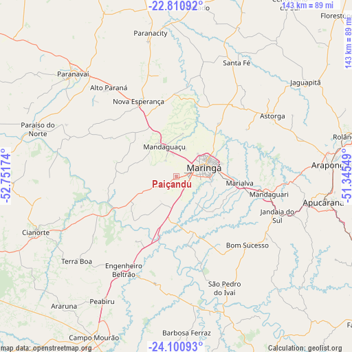
Paiçandu GPS coordinates[2]
23° 27' 27" South, 52° 2' 54.996" West
| Map corner | latitude | longitude |
|---|---|---|
| Upper-left | -22.81092°, | -52.75174° |
| Center: | -23.4575°, | -52.04861° |
| Lower-right: | -24.10093°, | -51.34549° |
| Map W x H: | 143.4×143.4 km | = 89.1×89.1mi |
| max Lat: | 2.81972° ⇑82.3% North |
| Paiçandu: | -23.4575° |
| min Lat: | ⇓17.7% South -33.69111° |
| min Long | Paiçandu | max Long |
| -72.89583° | -52.04861° | -32.41083° |
| W 12%⇐ | ⇒88% E |
Elevation
Elevation of Paiçandu is 486 m = 1594 ft, and this is 105.1 m = 345 ft above average elevation for this country.
| Max E: |
1603 m = 5259 ft | 38.6% |
| Paiçandu | 486 m 1594 ft | |
| Avg. | 380.9 m = 1250 ft | |
Min E: |
0 m = 0 ft | 61.4% |
See also: Brazil elevation on elevation.city.
Geographical zone
Paiçandu is located in South temperate zone (between Tropic of Capricorn and the Antarctic Circle). Distance of this Southern Tropic circle is 2.3 km =1.4 mi to North.| Distance of | km | miles | from Paiçandu |
|---|---|---|---|
| Equator | 2608.2 | 1620.7 | to North |
| Tropic Capricorn | 2.3 | 1.4 | to North |
| Antarctic Circle | 4792.9 | 2978.2 | to South |
| South Pole | 7398.8 | 4597.4 | to South |


Nearby cities:
15 places around Paiçandu: (largest is in red/bold)
• Alto Paraná
45.8 km =28.5 mi,  322°
322°
• Apucarana
60.8 km =37.8 mi,  99°
99°
• Arapongas
63.8 km =39.6 mi,  86°
86°
• Astorga
46.4 km =28.8 mi,  57°
57°
• Cianorte
61.2 km =38 mi,  248°
248°
• Engenheiro Beltrão
44 km =27.3 mi,  210°
210°
• Jandaia do Sul
44.4 km =27.6 mi,  111°
111°
• Mandaguari
39.8 km =24.7 mi, 104°
• Mandaguaçu
13.2 km =8.2 mi,  338°
338°
• Marialva
26.4 km =16.4 mi, 96°
• Maringá
11.8 km =7.3 mi,  72°
72°
• Paranavaí
60.3 km =37.5 mi, 315°
• Peabiru
58.8 km =36.5 mi, 210°
• Sarandi
17.9 km =11.1 mi, 85°
• Terra Boa
53.1 km =33 mi,  229°
229°
Sources, notices
• [Note1] Compared only with cities in Brazil existing in our database
• [Src1] Map data: © OpenStreetMap contributors (CC-BY-SA)
• [Src2] Other city data from geonames.org with taken over terms of usage.
• [Src3] Geographical zone / Annual Mean Temperature by Robert A. Rohde @ Wikipedia
