Tapejara geodata
Tapejara (Paraná) is a populated place; located in Brazil in America/Sao_Paulo (GMT-3) time zone. With population of 10,726 people, there are 1589 cities with bigger population in this country. Compared to other cities in Brazil, 84.7% of cities are located further ↑North; 90.2% of cities are located further →East and 64.2% of cities have lower elevation than Tapejara. Note1


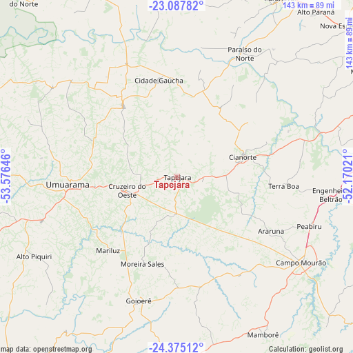
Tapejara GPS coordinates[2]
23° 43' 59.016" South, 52° 52' 23.988" West
| Map corner | latitude | longitude |
|---|---|---|
| Upper-left | -23.08782°, | -53.57646° |
| Center: | -23.73306°, | -52.87333° |
| Lower-right: | -24.37512°, | -52.17021° |
| Map W x H: | 143.1×143.1 km | = 88.9×88.9mi |
| max Lat: | 2.81972° ⇑84.7% North |
| Tapejara: | -23.73306° |
| min Lat: | ⇓15.3% South -33.69111° |
| min Long | Tapejara | max Long |
| -72.89583° | -52.87333° | -32.41083° |
| W 9.8%⇐ | ⇒90.2% E |
Elevation
Elevation of Tapejara is 518 m = 1699 ft, and this is 137.1 m = 450 ft above average elevation for this country.
| Max E: |
1603 m = 5259 ft | 35.8% |
| Tapejara | 518 m 1699 ft | |
| Avg. | 380.9 m = 1250 ft | |
Min E: |
0 m = 0 ft | 64.2% |
See also: Brazil elevation on elevation.city.
Geographical zone
Tapejara is located in South temperate zone (between Tropic of Capricorn and the Antarctic Circle). Distance of this Southern Tropic circle is 32.9 km =20.4 mi to North.| Distance of | km | miles | from Tapejara |
|---|---|---|---|
| Equator | 2638.9 | 1639.7 | to North |
| Tropic Capricorn | 32.9 | 20.4 | to North |
| Antarctic Circle | 4762.3 | 2959.2 | to South |
| South Pole | 7368.2 | 4578.4 | to South |


Nearby cities:
15 places around Tapejara: (largest is in red/bold)
• Alto Paraná
87.8 km =54.6 mi,  40°
40°
• Alto Piquiri
66.3 km =41.2 mi,  240°
240°
• Campo Mourão
60.9 km =37.8 mi,  124°
124°
• Cianorte
28.4 km =17.6 mi,  74°
74°
• Cruzeiro do Oeste
21.2 km =13.2 mi,  254°
254°
• Engenheiro Beltrão
61.9 km =38.5 mi,  96°
96°
• Iporã
89.7 km =55.7 mi, 250°
• Loanda
94 km =58.4 mi,  343°
343°
• Mandaguaçu
90.2 km =56 mi,  61°
61°
• Moreira Sales
39 km =24.2 mi,  200°
200°
• Paiçandu
89.4 km =55.6 mi, 69°
• Paranavaí
84.4 km =52.4 mi,  29°
29°
• Peabiru
57.5 km =35.7 mi,  110°
110°
• Terra Boa
43.8 km =27.2 mi, 95°
• Umuarama
46.1 km =28.6 mi,  265°
265°
Sources, notices
• [Note1] Compared only with cities in Brazil existing in our database
• [Src1] Map data: © OpenStreetMap contributors (CC-BY-SA)
• [Src2] Other city data from geonames.org with taken over terms of usage.
• [Src3] Geographical zone / Annual Mean Temperature by Robert A. Rohde @ Wikipedia
