Mandaguaçu geodata
Mandaguaçu (Paraná) is a populated place; located in Brazil in America/Sao_Paulo (GMT-3) time zone. With population of 14,866 people, there are 1221 cities with bigger population in this country. Compared to other cities in Brazil, 81.4% of cities are located further ↑North; 88% of cities are located further →East and 70.6% of cities have lower elevation than Mandaguaçu. Note1


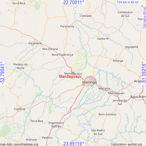
Mandaguaçu GPS coordinates[2]
23° 20' 49.992" South, 52° 5' 43.008" West
| Map corner | latitude | longitude |
|---|---|---|
| Upper-left | -22.70011°, | -52.79841° |
| Center: | -23.34722°, | -52.09528° |
| Lower-right: | -23.99119°, | -51.39216° |
| Map W x H: | 143.6×143.6 km | = 89.2×89.2mi |
| max Lat: | 2.81972° ⇑81.4% North |
| Mandaguaçu: | -23.34722° |
| min Lat: | ⇓18.6% South -33.69111° |
| min Long | Mandaguaçu | max Long |
| -72.89583° | -52.09528° | -32.41083° |
| W 12%⇐ | ⇒88% E |
Elevation
Elevation of Mandaguaçu is 580 m = 1903 ft, and this is 199.1 m = 653 ft above average elevation for this country.
| Max E: |
1603 m = 5259 ft | 29.4% |
| Mandaguaçu | 580 m 1903 ft | |
| Avg. | 380.9 m = 1250 ft | |
Min E: |
0 m = 0 ft | 70.6% |
See also: Brazil elevation on elevation.city.
Geographical zone
Mandaguaçu is located in South Torrid zone (between Equator and Tropic of Capricorn). Distance of this Southern Tropic circle is 10 km =6.2 mi to South.| Distance of | km | miles | from Mandaguaçu |
|---|---|---|---|
| Equator | 2596 | 1613.1 | to North |
| Tropic Capricorn | 10 | 6.2 | to South |
| Antarctic Circle | 4805.2 | 2985.8 | to South |
| South Pole | 7411.1 | 4605 | to South |


Nearby cities:
15 places around Mandaguaçu: (largest is in red/bold)
• Alto Paraná
33.3 km =20.7 mi,  316°
316°
• Apucarana
68.6 km =42.6 mi,  109°
109°
• Astorga
45.7 km =28.4 mi,  73°
73°
• Cianorte
62.7 km =39 mi,  235°
235°
• Colorado
58 km =36 mi,  12°
12°
• Engenheiro Beltrão
53.1 km =33 mi,  199°
199°
• Jandaia do Sul
54.2 km =33.7 mi,  121°
121°
• Mandaguari
48.7 km =30.3 mi, 117°
• Marialva
34.6 km =21.5 mi, 116°
• Maringá
18.2 km =11.3 mi, 118°
• Paiçandu
13.2 km =8.2 mi,  158°
158°
• Paranavaí
48.6 km =30.2 mi,  308°
308°
• Peabiru
67.8 km =42.1 mi, 201°
• Sarandi
25 km =15.5 mi, 115°
• Terra Boa
58.8 km =36.5 mi,  217°
217°
Sources, notices
• [Note1] Compared only with cities in Brazil existing in our database
• [Src1] Map data: © OpenStreetMap contributors (CC-BY-SA)
• [Src2] Other city data from geonames.org with taken over terms of usage.
• [Src3] Geographical zone / Annual Mean Temperature by Robert A. Rohde @ Wikipedia
