Cássia geodata
Cássia (Minas Gerais) is a populated place; located in Brazil in America/Sao_Paulo (GMT-3) time zone. With population of 14,391 people, there are 1260 cities with bigger population in this country. Compared to other cities in Brazil, 60.5% of cities are located further ↑North; 58% of cities are located further →East and 83.5% of cities have lower elevation than Cássia. Note1


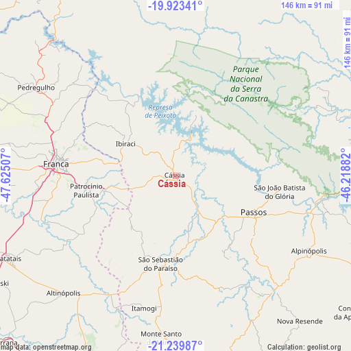
Cássia GPS coordinates[2]
20° 34' 59.016" South, 46° 55' 18.984" West
| Map corner | latitude | longitude |
|---|---|---|
| Upper-left | -19.92341°, | -47.62507° |
| Center: | -20.58306°, | -46.92194° |
| Lower-right: | -21.23987°, | -46.21882° |
| Map W x H: | 146.4×146.4 km | = 91×91mi |
| max Lat: | 2.81972° ⇑60.5% North |
| Cássia: | -20.58306° |
| min Lat: | ⇓39.5% South -33.69111° |
| min Long | Cássia | max Long |
| -72.89583° | -46.92194° | -32.41083° |
| W 42%⇐ | ⇒58% E |
Elevation
Elevation of Cássia is 740 m = 2428 ft, and this is 359.1 m = 1178 ft above average elevation for this country.
| Max E: |
1603 m = 5259 ft | 16.5% |
| Cássia | 740 m 2428 ft | |
| Avg. | 380.9 m = 1250 ft | |
Min E: |
0 m = 0 ft | 83.5% |
See also: Brazil elevation on elevation.city.
Geographical zone
Cássia is located in South Torrid zone (between Equator and Tropic of Capricorn). Distance of this Southern Tropic circle is 317.3 km =197.2 mi to South.| Distance of | km | miles | from Cássia |
|---|---|---|---|
| Equator | 2288.6 | 1422.1 | to North |
| Tropic Capricorn | 317.3 | 197.2 | to South |
| Antarctic Circle | 5112.6 | 3176.8 | to South |
| South Pole | 7718.4 | 4796 | to South |


Nearby cities:
15 places around Cássia: (largest is in red/bold)
• Alpinópolis
63.7 km =39.6 mi,  119°
119°
• Altinópolis
68 km =42.3 mi,  223°
223°
• Batatais
77 km =47.8 mi,  243°
243°
• Brodósqui
89 km =55.3 mi, 239°
• Cajuru
86.6 km =53.8 mi,  207°
207°
• Capitólio
90.8 km =56.4 mi,  92°
92°
• Franca
50.1 km =31.1 mi,  275°
275°
• Guaranésia
80.6 km =50.1 mi,  171°
171°
• Guaxupé
83.2 km =51.7 mi,  164°
164°
• Itaú de Minas
24.8 km =15.4 mi,  134°
134°
• Monte Santo de Minas
67.7 km =42.1 mi,  185°
185°
• Nuporanga
87.9 km =54.6 mi,  259°
259°
• Passos
35.8 km =22.2 mi,  114°
114°
• Pedregulho
68.2 km =42.4 mi,  302°
302°
• São Sebastião do Paraíso
37.8 km =23.5 mi, 191°
Sources, notices
• [Note1] Compared only with cities in Brazil existing in our database
• [Src1] Map data: © OpenStreetMap contributors (CC-BY-SA)
• [Src2] Other city data from geonames.org with taken over terms of usage.
• [Src3] Geographical zone / Annual Mean Temperature by Robert A. Rohde @ Wikipedia
