Brodósqui geodata
Brodósqui (São Paulo) is a populated place; located in Brazil in America/Sao_Paulo (GMT-3) time zone. With population of 18,366 people, there are 1019 cities with bigger population in this country. Compared to other cities in Brazil, 62.9% of cities are located further ↑North; 62.9% of cities are located further →East and 93.1% of cities have lower elevation than Brodósqui. Note1


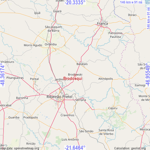
Brodósqui GPS coordinates[2]
20° 59' 29.004" South, 47° 39' 30.996" West
| Map corner | latitude | longitude |
|---|---|---|
| Upper-left | -20.3335°, | -48.36174° |
| Center: | -20.99139°, | -47.65861° |
| Lower-right: | -21.6464°, | -46.95549° |
| Map W x H: | 146×146 km | = 90.7×90.7mi |
| max Lat: | 2.81972° ⇑62.9% North |
| Brodósqui: | -20.99139° |
| min Lat: | ⇓37.1% South -33.69111° |
| min Long | Brodósqui | max Long |
| -72.89583° | -47.65861° | -32.41083° |
| W 37.1%⇐ | ⇒62.9% E |
Elevation
Elevation of Brodósqui is 866 m = 2841 ft, and this is 485.1 m = 1592 ft above average elevation for this country.
| Max E: |
1603 m = 5259 ft | 6.9% |
| Brodósqui | 866 m 2841 ft | |
| Avg. | 380.9 m = 1250 ft | |
Min E: |
0 m = 0 ft | 93.1% |
See also: Brazil elevation on elevation.city.
Geographical zone
Brodósqui is located in South Torrid zone (between Equator and Tropic of Capricorn). Distance of this Southern Tropic circle is 271.9 km =169 mi to South.| Distance of | km | miles | from Brodósqui |
|---|---|---|---|
| Equator | 2334 | 1450.3 | to North |
| Tropic Capricorn | 271.9 | 169 | to South |
| Antarctic Circle | 5067.2 | 3148.6 | to South |
| South Pole | 7673 | 4767.8 | to South |


Nearby cities:
15 places around Brodósqui: (largest is in red/bold)
• Altinópolis
29.8 km =18.5 mi,  97°
97°
• Batatais
13.5 km =8.4 mi,  34°
34°
• Cajuru
48.5 km =30.1 mi,  130°
130°
• Cravinhos
39.5 km =24.5 mi,  190°
190°
• Franca
57 km =35.4 mi, 28°
• Jardinópolis
11.3 km =7 mi,  254°
254°
• Morro Agudo
50.6 km =31.4 mi,  304°
304°
• Nuporanga
30.5 km =19 mi,  341°
341°
• Orlândia
38.3 km =23.8 mi,  321°
321°
• Pontal
39.5 km =24.5 mi,  264°
264°
• Ribeirão Preto
26 km =16.2 mi,  217°
217°
• Serrana
25.3 km =15.7 mi,  165°
165°
• Sertãozinho
38.1 km =23.7 mi,  244°
244°
• São Joaquim da Barra
49.9 km =31 mi, 335°
• São Simão
55.4 km =34.4 mi, 168°
Sources, notices
• [Note1] Compared only with cities in Brazil existing in our database
• [Src1] Map data: © OpenStreetMap contributors (CC-BY-SA)
• [Src2] Other city data from geonames.org with taken over terms of usage.
• [Src3] Geographical zone / Annual Mean Temperature by Robert A. Rohde @ Wikipedia
