Pedregulho geodata
Pedregulho (São Paulo) is a populated place; located in Brazil in America/Sao_Paulo (GMT-3) time zone. With population of 11,216 people, there are 1545 cities with bigger population in this country. Compared to other cities in Brazil, 58.5% of cities are located further ↑North; 61.5% of cities are located further →East and 98.9% of cities have lower elevation than Pedregulho. Note1


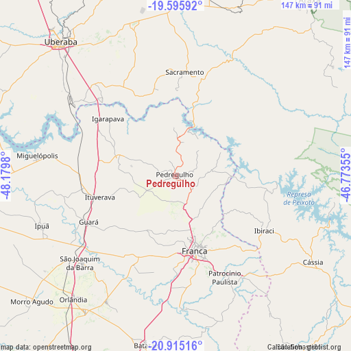
Pedregulho GPS coordinates[2]
20° 15' 24.984" South, 47° 28' 36.012" West
| Map corner | latitude | longitude |
|---|---|---|
| Upper-left | -19.59592°, | -48.1798° |
| Center: | -20.25694°, | -47.47667° |
| Lower-right: | -20.91516°, | -46.77355° |
| Map W x H: | 146.7×146.7 km | = 91.2×91.2mi |
| max Lat: | 2.81972° ⇑58.5% North |
| Pedregulho: | -20.25694° |
| min Lat: | ⇓41.5% South -33.69111° |
| min Long | Pedregulho | max Long |
| -72.89583° | -47.47667° | -32.41083° |
| W 38.5%⇐ | ⇒61.5% E |
Elevation
Elevation of Pedregulho is 1044 m = 3425 ft, and this is 663.1 m = 2176 ft above average elevation for this country.
| Max E: |
1603 m = 5259 ft | 1.1% |
| Pedregulho | 1044 m 3425 ft | |
| Avg. | 380.9 m = 1250 ft | |
Min E: |
0 m = 0 ft | 98.9% |
See also: Brazil elevation on elevation.city.
Geographical zone
Pedregulho is located in South Torrid zone (between Equator and Tropic of Capricorn). Distance of this Southern Tropic circle is 353.6 km =219.7 mi to South.| Distance of | km | miles | from Pedregulho |
|---|---|---|---|
| Equator | 2252.4 | 1399.6 | to North |
| Tropic Capricorn | 353.6 | 219.7 | to South |
| Antarctic Circle | 5148.8 | 3199.3 | to South |
| South Pole | 7754.7 | 4818.5 | to South |


Nearby cities:
15 places around Pedregulho: (largest is in red/bold)
• Batatais
71.4 km =44.4 mi,  189°
189°
• Brodósqui
83.8 km =52.1 mi, 193°
• Cássia
68.2 km =42.4 mi,  122°
122°
• Franca
32.3 km =20.1 mi,  165°
165°
• Guará
40.9 km =25.4 mi,  242°
242°
• Igarapava
37.2 km =23.1 mi,  310°
310°
• Ipuã
59.4 km =36.9 mi,  250°
250°
• Ituverava
33 km =20.5 mi, 253°
• Miguelópolis
58.6 km =36.4 mi,  278°
278°
• Morro Agudo
80.3 km =49.9 mi,  228°
228°
• Nuporanga
60 km =37.3 mi,  208°
208°
• Orlândia
66.9 km =41.6 mi,  219°
219°
• Sacramento
43.7 km =27.2 mi,  5°
5°
• São Joaquim da Barra
53.4 km =33.2 mi, 227°
• Uberaba
73.9 km =45.9 mi,  319°
319°
Sources, notices
• [Note1] Compared only with cities in Brazil existing in our database
• [Src1] Map data: © OpenStreetMap contributors (CC-BY-SA)
• [Src2] Other city data from geonames.org with taken over terms of usage.
• [Src3] Geographical zone / Annual Mean Temperature by Robert A. Rohde @ Wikipedia
