Campo Grande geodata
Campo Grande (Mato Grosso do Sul) is a seat of a first-order administrative division; located in Brazil in America/Campo_Grande (GMT-4) time zone. With population of 729,151 people, there are 21 cities with bigger population in this country. Compared to other cities in Brazil, 59.8% of cities are located further ↑North; 93.6% of cities are located further →East and 71.9% of cities have lower elevation than Campo Grande. Note1


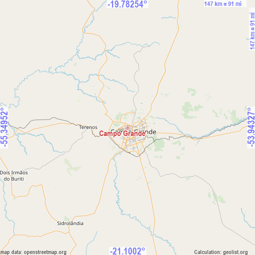
Campo Grande GPS coordinates[2]
20° 26' 34.008" South, 54° 38' 47.004" West
| Map corner | latitude | longitude |
|---|---|---|
| Upper-left | -19.78254°, | -55.34952° |
| Center: | -20.44278°, | -54.64639° |
| Lower-right: | -21.1002°, | -53.94327° |
| Map W x H: | 146.5×146.5 km | = 91×91mi |
| max Lat: | 2.81972° ⇑59.8% North |
| Campo Grande: | -20.44278° |
| min Lat: | ⇓40.2% South -33.69111° |
| min Long | Campo Grande | max Long |
| -72.89583° | -54.64639° | -32.41083° |
| W 6.4%⇐ | ⇒93.6% E |
Elevation
Elevation of Campo Grande is 592 m = 1942 ft, and this is 211.1 m = 693 ft above average elevation for this country.
| Max E: |
1603 m = 5259 ft | 28.1% |
| Campo Grande | 592 m 1942 ft | |
| Avg. | 380.9 m = 1250 ft | |
Min E: |
0 m = 0 ft | 71.9% |
See also: Campo Grande elevation on elevation.city.
Geographical zone
Campo Grande is located in South Torrid zone (between Equator and Tropic of Capricorn). Distance of this Southern Tropic circle is 332.9 km =206.9 mi to South.| Distance of | km | miles | from Campo Grande |
|---|---|---|---|
| Equator | 2273 | 1412.4 | to North |
| Tropic Capricorn | 332.9 | 206.9 | to South |
| Antarctic Circle | 5128.2 | 3186.5 | to South |
| South Pole | 7734 | 4805.7 | to South |


Nearby cities:
15 places around Campo Grande: (largest is in red/bold)
• Anastácio
121 km =75.2 mi,  267°
267°
• Aquidauana
118.9 km =73.9 mi, 268°
• Bonito
205.2 km =127.5 mi,  248°
248°
• Camapuã
119.3 km =74.1 mi,  31°
31°
• Campo Verde
60.5 km =37.6 mi,  87°
87°
• Dourados
198.4 km =123.3 mi,  184°
184°
• Guia Lopes da Laguna
189.6 km =117.8 mi,  233°
233°
• Jardim
193.1 km =120 mi, 233°
• Maracaju
141.1 km =87.7 mi,  202°
202°
• Miranda
182 km =113.1 mi,  277°
277°
• Ribas do Rio Pardo
92.4 km =57.4 mi, 90°
• Rio Brilhante
151.5 km =94.1 mi, 176°
• Rio Verde de Mato Grosso
170.8 km =106.1 mi,  353°
353°
• Sidrolândia
63.5 km =39.5 mi,  211°
211°
• Terenos
22.3 km =13.9 mi, 270°
Sources, notices
• [Note1] Compared only with cities in Brazil existing in our database
• [Src1] Map data: © OpenStreetMap contributors (CC-BY-SA)
• [Src2] Other city data from geonames.org with taken over terms of usage.
• [Src3] Geographical zone / Annual Mean Temperature by Robert A. Rohde @ Wikipedia
