Anastácio geodata
Anastácio (Mato Grosso do Sul) is a populated place; located in Brazil in America/Campo_Grande (GMT-4) time zone. With population of 18,817 people, there are 994 cities with bigger population in this country. Compared to other cities in Brazil, 60.1% of cities are located further ↑North; 94.9% of cities are located further →East and 64.6% of cities have higher elevation than Anastácio. Note1


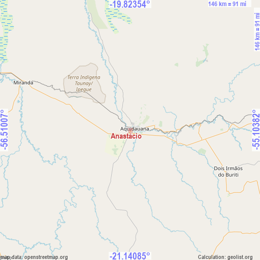
Anastácio GPS coordinates[2]
20° 29' 0.996" South, 55° 48' 24.984" West
| Map corner | latitude | longitude |
|---|---|---|
| Upper-left | -19.82354°, | -56.51007° |
| Center: | -20.48361°, | -55.80694° |
| Lower-right: | -21.14085°, | -55.10382° |
| Map W x H: | 146.5×146.5 km | = 91×91mi |
| max Lat: | 2.81972° ⇑60.1% North |
| Anastácio: | -20.48361° |
| min Lat: | ⇓39.9% South -33.69111° |
| min Long | Anastácio | max Long |
| -72.89583° | -55.80694° | -32.41083° |
| W 5.1%⇐ | ⇒94.9% E |
Elevation
Elevation of Anastácio is 170 m = 558 ft, and this is 210.9 m = 692 ft below average elevation for this country.
| Max E: |
1603 m = 5259 ft | 64.6% |
| Avg. | 380.9 m = 1250 ft | |
| Anastácio | 170 m = 558 ft | |
Min E: |
0 m = 0 ft | 35.4% |
See also: Brazil elevation on elevation.city.
Geographical zone
Anastácio is located in South Torrid zone (between Equator and Tropic of Capricorn). Distance of this Southern Tropic circle is 328.4 km =204.1 mi to South.| Distance of | km | miles | from Anastácio |
|---|---|---|---|
| Equator | 2277.6 | 1415.2 | to North |
| Tropic Capricorn | 328.4 | 204.1 | to South |
| Antarctic Circle | 5123.6 | 3183.7 | to South |
| South Pole | 7729.5 | 4802.9 | to South |


Nearby cities:
15 places around Anastácio: (largest is in red/bold)
• Aquidauana
2.5 km =1.6 mi,  55°
55°
• Bela Vista
195.3 km =121.4 mi,  202°
202°
• Bonito
99.7 km =62 mi,  224°
224°
• Camapuã
212.5 km =132 mi, 60°
• Campo Grande
121 km =75.2 mi,  87°
87°
• Campo Verde
181.5 km =112.8 mi, 87°
• Guia Lopes da Laguna
112.9 km =70.2 mi, 196°
• Jardim
116 km =72.1 mi, 197°
• Maracaju
142.1 km =88.3 mi,  152°
152°
• Miranda
65.4 km =40.6 mi,  294°
294°
• Ribas do Rio Pardo
213.4 km =132.6 mi, 88°
• Rio Brilhante
196.4 km =122 mi,  138°
138°
• Rio Verde de Mato Grosso
201.1 km =125 mi,  30°
30°
• Sidrolândia
101.1 km =62.8 mi,  119°
119°
• Terenos
98.7 km =61.3 mi, 87°
Sources, notices
• [Note1] Compared only with cities in Brazil existing in our database
• [Src1] Map data: © OpenStreetMap contributors (CC-BY-SA)
• [Src2] Other city data from geonames.org with taken over terms of usage.
• [Src3] Geographical zone / Annual Mean Temperature by Robert A. Rohde @ Wikipedia
