Jardim geodata
Jardim (Mato Grosso do Sul) is a populated place; located in Brazil in America/Campo_Grande (GMT-4) time zone. With population of 23,780 people, there are 811 cities with bigger population in this country. Compared to other cities in Brazil, 66.5% of cities are located further ↑North; 95.6% of cities are located further →East and 55.8% of cities have higher elevation than Jardim. Note1


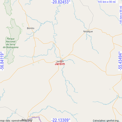
Jardim GPS coordinates[2]
21° 28' 49.008" South, 56° 8' 17.016" West
| Map corner | latitude | longitude |
|---|---|---|
| Upper-left | -20.82453°, | -56.84119° |
| Center: | -21.48028°, | -56.13806° |
| Lower-right: | -22.13309°, | -55.43494° |
| Map W x H: | 145.5×145.5 km | = 90.4×90.4mi |
| max Lat: | 2.81972° ⇑66.5% North |
| Jardim: | -21.48028° |
| min Lat: | ⇓33.5% South -33.69111° |
| min Long | Jardim | max Long |
| -72.89583° | -56.13806° | -32.41083° |
| W 4.4%⇐ | ⇒95.6% E |
Elevation
Elevation of Jardim is 256 m = 840 ft, and this is 124.9 m = 410 ft below average elevation for this country.
| Max E: |
1603 m = 5259 ft | 55.8% |
| Avg. | 380.9 m = 1250 ft | |
| Jardim | 256 m = 840 ft | |
Min E: |
0 m = 0 ft | 44.2% |
See also: Brazil elevation on elevation.city.
Geographical zone
Jardim is located in South Torrid zone (between Equator and Tropic of Capricorn). Distance of this Southern Tropic circle is 217.5 km =135.1 mi to South.| Distance of | km | miles | from Jardim |
|---|---|---|---|
| Equator | 2388.4 | 1484.1 | to North |
| Tropic Capricorn | 217.5 | 135.1 | to South |
| Antarctic Circle | 5012.8 | 3114.8 | to South |
| South Pole | 7618.7 | 4734 | to South |


Nearby cities:
15 places around Jardim: (largest is in red/bold)
• Anastácio
116 km =72.1 mi,  17°
17°
• Aquidauana
118 km =73.3 mi, 17°
• Bela Vista
80.3 km =49.9 mi,  209°
209°
• Bonito
53.5 km =33.2 mi,  318°
318°
• Caarapó
186.7 km =116 mi,  133°
133°
• Campo Grande
193.1 km =120 mi,  53°
53°
• Dourados
160.3 km =99.6 mi,  120°
120°
• Guia Lopes da Laguna
3.5 km =2.2 mi,  44°
44°
• Maracaju
101.4 km =63 mi,  98°
98°
• Miranda
140.1 km =87.1 mi,  349°
349°
• Ponta Porã
124.9 km =77.6 mi,  160°
160°
• Porto Murtinho
182 km =113.1 mi,  262°
262°
• Rio Brilhante
168.3 km =104.6 mi, 102°
• Sidrolândia
136.4 km =84.8 mi,  63°
63°
• Terenos
175.9 km =109.3 mi, 48°
Sources, notices
• [Note1] Compared only with cities in Brazil existing in our database
• [Src1] Map data: © OpenStreetMap contributors (CC-BY-SA)
• [Src2] Other city data from geonames.org with taken over terms of usage.
• [Src3] Geographical zone / Annual Mean Temperature by Robert A. Rohde @ Wikipedia
