Miranda geodata
Miranda (Mato Grosso do Sul) is a populated place; located in Brazil in America/Campo_Grande (GMT-4) time zone. With population of 13,189 people, there are 1358 cities with bigger population in this country. Compared to other cities in Brazil, 58.4% of cities are located further ↑North; 95.7% of cities are located further →East and 69.2% of cities have higher elevation than Miranda. Note1


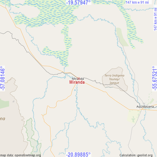
Miranda GPS coordinates[2]
20° 14' 26.016" South, 56° 22' 41.988" West
| Map corner | latitude | longitude |
|---|---|---|
| Upper-left | -19.57947°, | -57.08146° |
| Center: | -20.24056°, | -56.37833° |
| Lower-right: | -20.89885°, | -55.67521° |
| Map W x H: | 146.7×146.7 km | = 91.2×91.2mi |
| max Lat: | 2.81972° ⇑58.4% North |
| Miranda: | -20.24056° |
| min Lat: | ⇓41.6% South -33.69111° |
| min Long | Miranda | max Long |
| -72.89583° | -56.37833° | -32.41083° |
| W 4.3%⇐ | ⇒95.7% E |
Elevation
Elevation of Miranda is 131 m = 430 ft, and this is 249.9 m = 820 ft below average elevation for this country.
| Max E: |
1603 m = 5259 ft | 69.2% |
| Avg. | 380.9 m = 1250 ft | |
| Miranda | 131 m = 430 ft | |
Min E: |
0 m = 0 ft | 30.8% |
See also: Brazil elevation on elevation.city.
Geographical zone
Miranda is located in South Torrid zone (between Equator and Tropic of Capricorn). Distance of this Southern Tropic circle is 355.4 km =220.8 mi to South.| Distance of | km | miles | from Miranda |
|---|---|---|---|
| Equator | 2250.5 | 1398.4 | to North |
| Tropic Capricorn | 355.4 | 220.8 | to South |
| Antarctic Circle | 5150.6 | 3200.4 | to South |
| South Pole | 7756.5 | 4819.7 | to South |


Nearby cities:
15 places around Miranda: (largest is in red/bold)
• Anastácio
65.4 km =40.6 mi,  114°
114°
• Aquidauana
66.7 km =41.4 mi, 112°
• Bela Vista
208.3 km =129.4 mi,  184°
184°
• Bonito
98.5 km =61.2 mi,  186°
186°
• Campo Grande
182 km =113.1 mi,  97°
97°
• Campo Verde
241.8 km =150.2 mi,  94°
94°
• Corumbá
191.2 km =118.8 mi,  315°
315°
• Guia Lopes da Laguna
138.1 km =85.8 mi,  168°
168°
• Jardim
140.1 km =87.1 mi, 169°
• Ladário
187.9 km =116.8 mi, 317°
• Maracaju
197.8 km =122.9 mi,  140°
140°
• Porto Murtinho
225.1 km =139.9 mi,  223°
223°
• Rio Verde de Mato Grosso
217.8 km =135.3 mi,  47°
47°
• Sidrolândia
166.3 km =103.3 mi,  117°
117°
• Terenos
159.8 km =99.3 mi, 98°
Sources, notices
• [Note1] Compared only with cities in Brazil existing in our database
• [Src1] Map data: © OpenStreetMap contributors (CC-BY-SA)
• [Src2] Other city data from geonames.org with taken over terms of usage.
• [Src3] Geographical zone / Annual Mean Temperature by Robert A. Rohde @ Wikipedia
