Camanducaia geodata
Camanducaia (Minas Gerais) is a populated place; located in Brazil in America/Sao_Paulo (GMT-3) time zone. With population of 17,822 people, there are 1050 cities with bigger population in this country. Compared to other cities in Brazil, 76.2% of cities are located further ↑North; 53.1% of cities are located further →East and 98.6% of cities have lower elevation than Camanducaia. Note1


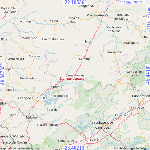
Camanducaia GPS coordinates[2]
22° 45' 19.008" South, 46° 8' 40.992" West
| Map corner | latitude | longitude |
|---|---|---|
| Upper-left | -22.10536°, | -46.84785° |
| Center: | -22.75528°, | -46.14472° |
| Lower-right: | -23.40213°, | -45.4416° |
| Map W x H: | 144.2×144.2 km | = 89.6×89.6mi |
| max Lat: | 2.81972° ⇑76.2% North |
| Camanducaia: | -22.75528° |
| min Lat: | ⇓23.8% South -33.69111° |
| min Long | Camanducaia | max Long |
| -72.89583° | -46.14472° | -32.41083° |
| W 46.9%⇐ | ⇒53.1% E |
Elevation
Elevation of Camanducaia is 1012 m = 3320 ft, and this is 631.1 m = 2071 ft above average elevation for this country.
| Max E: |
1603 m = 5259 ft | 1.4% |
| Camanducaia | 1012 m 3320 ft | |
| Avg. | 380.9 m = 1250 ft | |
Min E: |
0 m = 0 ft | 98.6% |
See also: Brazil elevation on elevation.city.
Geographical zone
Camanducaia is located in South Torrid zone (between Equator and Tropic of Capricorn). Distance of this Southern Tropic circle is 75.8 km =47.1 mi to South.| Distance of | km | miles | from Camanducaia |
|---|---|---|---|
| Equator | 2530.1 | 1572.1 | to North |
| Tropic Capricorn | 75.8 | 47.1 | to South |
| Antarctic Circle | 4871 | 3026.7 | to South |
| South Pole | 7476.9 | 4645.9 | to South |


Nearby cities:
15 places around Camanducaia: (largest is in red/bold)
• Atibaia
57.8 km =35.9 mi,  225°
225°
• Bom Jesus dos Perdões
53.5 km =33.2 mi,  217°
217°
• Borda da Mata
53.5 km =33.2 mi,  357°
357°
• Bragança Paulista
46.4 km =28.8 mi,  241°
241°
• Bueno Brandão
40.9 km =25.4 mi,  328°
328°
• Cambuí
18.3 km =11.4 mi,  29°
29°
• Campos do Jordão
56.8 km =35.3 mi,  88°
88°
• Extrema
20.9 km =13 mi, 238°
• Joanópolis
23.6 km =14.7 mi,  214°
214°
• Monte Sião
56.7 km =35.2 mi,  309°
309°
• Monte Verde
16.5 km =10.3 mi,  137°
137°
• Paraisópolis
43.6 km =27.1 mi,  59°
59°
• Piracaia
39.7 km =24.7 mi, 213°
• Socorro
43.4 km =27 mi,  294°
294°
• São José dos Campos
54 km =33.6 mi,  150°
150°
Sources, notices
• [Note1] Compared only with cities in Brazil existing in our database
• [Src1] Map data: © OpenStreetMap contributors (CC-BY-SA)
• [Src2] Other city data from geonames.org with taken over terms of usage.
• [Src3] Geographical zone / Annual Mean Temperature by Robert A. Rohde @ Wikipedia
