Bueno Brandão geodata
Bueno Brandão (Minas Gerais) is a populated place; located in Brazil in America/Sao_Paulo (GMT-3) time zone. With population of 5,777 people, there are 1885 cities with bigger population in this country. Compared to other cities in Brazil, 73.1% of cities are located further ↑North; 54% of cities are located further →East and 99.7% of cities have lower elevation than Bueno Brandão. Note1


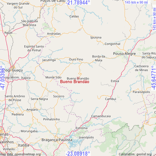
Bueno Brandão GPS coordinates[2]
22° 26' 26.988" South, 46° 21' 2.988" West
| Map corner | latitude | longitude |
|---|---|---|
| Upper-left | -21.78944°, | -47.05396° |
| Center: | -22.44083°, | -46.35083° |
| Lower-right: | -23.08918°, | -45.64771° |
| Map W x H: | 144.5×144.5 km | = 89.8×89.8mi |
| max Lat: | 2.81972° ⇑73.1% North |
| Bueno Brandão: | -22.44083° |
| min Lat: | ⇓26.9% South -33.69111° |
| min Long | Bueno Brandão | max Long |
| -72.89583° | -46.35083° | -32.41083° |
| W 46%⇐ | ⇒54% E |
Elevation
Elevation of Bueno Brandão is 1184 m = 3885 ft, and this is 803.1 m = 2635 ft above average elevation for this country.
| Max E: |
1603 m = 5259 ft | 0.3% |
| Bueno Brandão | 1184 m 3885 ft | |
| Avg. | 380.9 m = 1250 ft | |
Min E: |
0 m = 0 ft | 99.7% |
See also: Brazil elevation on elevation.city.
Geographical zone
Bueno Brandão is located in South Torrid zone (between Equator and Tropic of Capricorn). Distance of this Southern Tropic circle is 110.7 km =68.8 mi to South.| Distance of | km | miles | from Bueno Brandão |
|---|---|---|---|
| Equator | 2495.2 | 1550.4 | to North |
| Tropic Capricorn | 110.7 | 68.8 | to South |
| Antarctic Circle | 4906 | 3048.4 | to South |
| South Pole | 7511.9 | 4667.7 | to South |


Nearby cities:
15 places around Bueno Brandão: (largest is in red/bold)
• Amparo
51.4 km =31.9 mi,  235°
235°
• Andradas
47.1 km =29.3 mi,  331°
331°
• Borda da Mata
26.6 km =16.5 mi,  45°
45°
• Camanducaia
40.9 km =25.4 mi,  148°
148°
• Cambuí
35.6 km =22.1 mi,  122°
122°
• Espírito Santo do Pinhal
49.7 km =30.9 mi,  316°
316°
• Extrema
46.1 km =28.6 mi,  175°
175°
• Itapira
48.4 km =30.1 mi,  270°
270°
• Jacutinga
31.9 km =19.8 mi,  302°
302°
• Joanópolis
55 km =34.2 mi,  171°
171°
• Monte Sião
22.8 km =14.2 mi, 272°
• Pouso Alegre
48.6 km =30.2 mi,  61°
61°
• Serra Negra
40.7 km =25.3 mi, 242°
• Socorro
24.8 km =15.4 mi,  227°
227°
• Águas de Lindóia
29.2 km =18.1 mi,  262°
262°
Sources, notices
• [Note1] Compared only with cities in Brazil existing in our database
• [Src1] Map data: © OpenStreetMap contributors (CC-BY-SA)
• [Src2] Other city data from geonames.org with taken over terms of usage.
• [Src3] Geographical zone / Annual Mean Temperature by Robert A. Rohde @ Wikipedia
