Monte Verde geodata
Monte Verde (Minas Gerais) is a populated locality; located in Brazil in America/Sao_Paulo (GMT-3) time zone. With population of 4,132 people, there are 1959 cities with bigger population in this country. Compared to other cities in Brazil, 77.4% of cities are located further ↑North; 52.5% of cities are located further →East and 100% of cities have lower elevation than Monte Verde. Note1


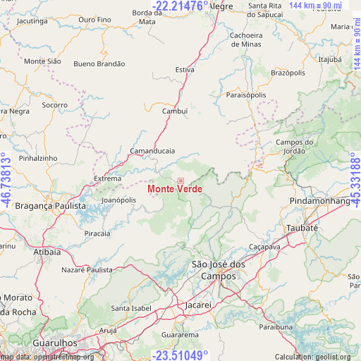
Monte Verde GPS coordinates[2]
22° 51' 51.012" South, 46° 2' 6" West
| Map corner | latitude | longitude |
|---|---|---|
| Upper-left | -22.21476°, | -46.73813° |
| Center: | -22.86417°, | -46.035° |
| Lower-right: | -23.51049°, | -45.33188° |
| Map W x H: | 144.1×144.1 km | = 89.5×89.5mi |
| max Lat: | 2.81972° ⇑77.4% North |
| Monte Verde: | -22.86417° |
| min Lat: | ⇓22.6% South -33.69111° |
| min Long | Monte Verde | max Long |
| -72.89583° | -46.035° | -32.41083° |
| W 47.5%⇐ | ⇒52.5% E |
Elevation
Elevation of Monte Verde is 1551 m = 5089 ft, and this is 1170.1 m = 3839 ft above average elevation for this country.
| Max E: |
1603 m = 5259 ft | 0% |
| Monte Verde | 1551 m 5089 ft | |
| Avg. | 380.9 m = 1250 ft | |
Min E: |
0 m = 0 ft | 100% |
See also: Brazil elevation on elevation.city.
Geographical zone
Monte Verde is located in South Torrid zone (between Equator and Tropic of Capricorn). Distance of this Southern Tropic circle is 63.7 km =39.6 mi to South.| Distance of | km | miles | from Monte Verde |
|---|---|---|---|
| Equator | 2542.3 | 1579.7 | to North |
| Tropic Capricorn | 63.7 | 39.6 | to South |
| Antarctic Circle | 4858.9 | 3019.2 | to South |
| South Pole | 7464.8 | 4638.4 | to South |


Nearby cities:
15 places around Monte Verde: (largest is in red/bold)
• Bom Jesus dos Perdões
53.4 km =33.2 mi,  235°
235°
• Bragança Paulista
53.1 km =33 mi,  259°
259°
• Camanducaia
16.5 km =10.3 mi,  317°
317°
• Cambuí
28.1 km =17.5 mi,  355°
355°
• Campos do Jordão
47.5 km =29.5 mi,  73°
73°
• Caçapava
42.7 km =26.5 mi,  128°
128°
• Extrema
29 km =18 mi,  272°
272°
• Jacareí
49.6 km =30.8 mi,  171°
171°
• Joanópolis
25.7 km =16 mi,  253°
253°
• Paraisópolis
43.3 km =26.9 mi,  37°
37°
• Piracaia
39.2 km =24.4 mi, 237°
• Santa Isabel
53.7 km =33.4 mi,  200°
200°
• São José dos Campos
38.2 km =23.7 mi,  156°
156°
• Taubaté
52.3 km =32.5 mi,  110°
110°
• Tremembé
50.8 km =31.6 mi,  101°
101°
Sources, notices
• [Note1] Compared only with cities in Brazil existing in our database
• [Src1] Map data: © OpenStreetMap contributors (CC-BY-SA)
• [Src2] Other city data from geonames.org with taken over terms of usage.
• [Src3] Geographical zone / Annual Mean Temperature by Robert A. Rohde @ Wikipedia
