Orlândia geodata
Orlândia (São Paulo) is a populated place; located in Brazil in America/Sao_Paulo (GMT-3) time zone. With population of 44,766 people, there are 478 cities with bigger population in this country. Compared to other cities in Brazil, 61.2% of cities are located further ↑North; 64% of cities are located further →East and 80.8% of cities have lower elevation than Orlândia. Note1


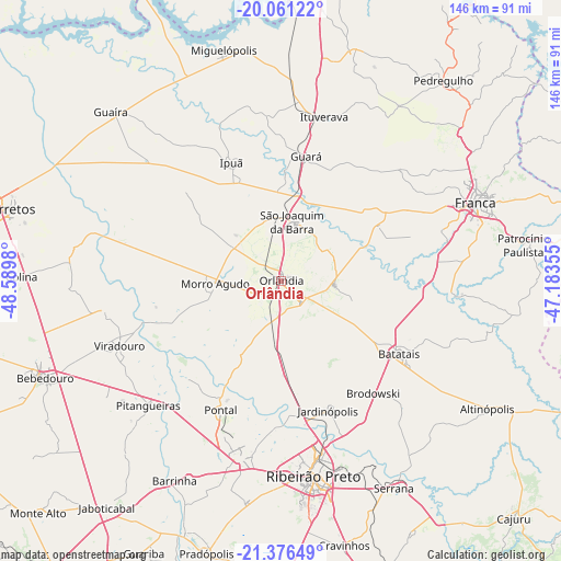
Orlândia GPS coordinates[2]
20° 43' 13.008" South, 47° 53' 12.012" West
| Map corner | latitude | longitude |
|---|---|---|
| Upper-left | -20.06122°, | -48.5898° |
| Center: | -20.72028°, | -47.88667° |
| Lower-right: | -21.37649°, | -47.18355° |
| Map W x H: | 146.2×146.2 km | = 90.8×90.8mi |
| max Lat: | 2.81972° ⇑61.2% North |
| Orlândia: | -20.72028° |
| min Lat: | ⇓38.8% South -33.69111° |
| min Long | Orlândia | max Long |
| -72.89583° | -47.88667° | -32.41083° |
| W 36%⇐ | ⇒64% E |
Elevation
Elevation of Orlândia is 700 m = 2297 ft, and this is 319.1 m = 1047 ft above average elevation for this country.
| Max E: |
1603 m = 5259 ft | 19.2% |
| Orlândia | 700 m 2297 ft | |
| Avg. | 380.9 m = 1250 ft | |
Min E: |
0 m = 0 ft | 80.8% |
See also: Orlândia elevation on elevation.city.
Geographical zone
Orlândia is located in South Torrid zone (between Equator and Tropic of Capricorn). Distance of this Southern Tropic circle is 302 km =187.7 mi to South.| Distance of | km | miles | from Orlândia |
|---|---|---|---|
| Equator | 2303.9 | 1431.6 | to North |
| Tropic Capricorn | 302 | 187.7 | to South |
| Antarctic Circle | 5097.3 | 3167.3 | to South |
| South Pole | 7703.2 | 4786.5 | to South |


Nearby cities:
15 places around Orlândia: (largest is in red/bold)
• Batatais
36.7 km =22.8 mi,  121°
121°
• Brodósqui
38.3 km =23.8 mi,  141°
141°
• Franca
54.4 km =33.8 mi,  68°
68°
• Guará
33.1 km =20.6 mi,  11°
11°
• Ipuã
34 km =21.1 mi,  337°
337°
• Ituverava
43.8 km =27.2 mi, 14°
• Jardinópolis
35.5 km =22.1 mi,  158°
158°
• Morro Agudo
17.8 km =11.1 mi,  266°
266°
• Nuporanga
14.1 km =8.8 mi,  94°
94°
• Pitangueiras
47.4 km =29.5 mi,  227°
227°
• Pontal
37.1 km =23.1 mi,  204°
204°
• Ribeirão Preto
51.5 km =32 mi,  171°
171°
• Sertãozinho
47.7 km =29.6 mi,  193°
193°
• São Joaquim da Barra
15.8 km =9.8 mi, 12°
• Viradouro
45.9 km =28.5 mi,  248°
248°
Sources, notices
• [Note1] Compared only with cities in Brazil existing in our database
• [Src1] Map data: © OpenStreetMap contributors (CC-BY-SA)
• [Src2] Other city data from geonames.org with taken over terms of usage.
• [Src3] Geographical zone / Annual Mean Temperature by Robert A. Rohde @ Wikipedia
