Barra Mansa geodata
Barra Mansa (Rio de Janeiro) is a populated place; located in Brazil in America/Sao_Paulo (GMT-3) time zone. With population of 164,052 people, there are 140 cities with bigger population in this country. Compared to other cities in Brazil, 74.3% of cities are located further ↑North; 55% of cities are located further ←West and 52.2% of cities have lower elevation than Barra Mansa. Note1


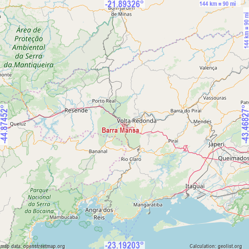
Barra Mansa GPS coordinates[2]
22° 32' 39.012" South, 44° 10' 17.004" West
| Map corner | latitude | longitude |
|---|---|---|
| Upper-left | -21.89326°, | -44.87452° |
| Center: | -22.54417°, | -44.17139° |
| Lower-right: | -23.19203°, | -43.46827° |
| Map W x H: | 144.4×144.4 km | = 89.7×89.7mi |
| max Lat: | 2.81972° ⇑74.3% North |
| Barra Mansa: | -22.54417° |
| min Lat: | ⇓25.7% South -33.69111° |
| min Long | Barra Mansa | max Long |
| -72.89583° | -44.17139° | -32.41083° |
| W 55%⇐ | ⇒45% E |
Elevation
Elevation of Barra Mansa is 380 m = 1247 ft, and this is 0.89999999999998 m = 3 ft below average elevation for this country.
| Max E: |
1603 m = 5259 ft | 47.8% |
| Avg. | 380.9 m = 1250 ft | |
| Barra Mansa | 380 m = 1247 ft | |
Min E: |
0 m = 0 ft | 52.2% |
See also: Barra Mansa elevation on elevation.city.
Geographical zone
Barra Mansa is located in South Torrid zone (between Equator and Tropic of Capricorn). Distance of this Southern Tropic circle is 99.2 km =61.6 mi to South.| Distance of | km | miles | from Barra Mansa |
|---|---|---|---|
| Equator | 2506.7 | 1557.6 | to North |
| Tropic Capricorn | 99.2 | 61.6 | to South |
| Antarctic Circle | 4894.5 | 3041.3 | to South |
| South Pole | 7500.4 | 4660.5 | to South |


Nearby cities:
15 places around Barra Mansa: (largest is in red/bold)
• Angra dos Reis
53.6 km =33.3 mi,  196°
196°
• Barra do Piraí
36.5 km =22.7 mi,  76°
76°
• Itaguaí
53.1 km =33 mi,  130°
130°
• Itatiaia
40.6 km =25.2 mi,  277°
277°
• Mangaratiba
48.1 km =29.9 mi,  163°
163°
• Mendes
45.1 km =28 mi,  87°
87°
• Paracambi
48.1 km =29.9 mi,  98°
98°
• Pinheiral
17.9 km =11.1 mi, 78°
• Piraí
29.6 km =18.4 mi,  108°
108°
• Porto Real
18.5 km =11.5 mi,  318°
318°
• Quatis
17.6 km =10.9 mi,  329°
329°
• Resende
29.5 km =18.3 mi,  286°
286°
• Rio Claro
20.2 km =12.6 mi,  169°
169°
• Seropédica
52.5 km =32.6 mi,  115°
115°
• Volta Redonda
7.3 km =4.5 mi,  71°
71°
Sources, notices
• [Note1] Compared only with cities in Brazil existing in our database
• [Src1] Map data: © OpenStreetMap contributors (CC-BY-SA)
• [Src2] Other city data from geonames.org with taken over terms of usage.
• [Src3] Geographical zone / Annual Mean Temperature by Robert A. Rohde @ Wikipedia
