Palmas geodata
Palmas (Tocantins) is a seat of a first-order administrative division; located in Brazil in America/Araguaina (GMT-3) time zone. With population of 196,272 people, there are 117 cities with bigger population in this country. Compared to other cities in Brazil, 67.5% of cities are located further ↓South; 66.2% of cities are located further →East and 54.8% of cities have higher elevation than Palmas. Note1


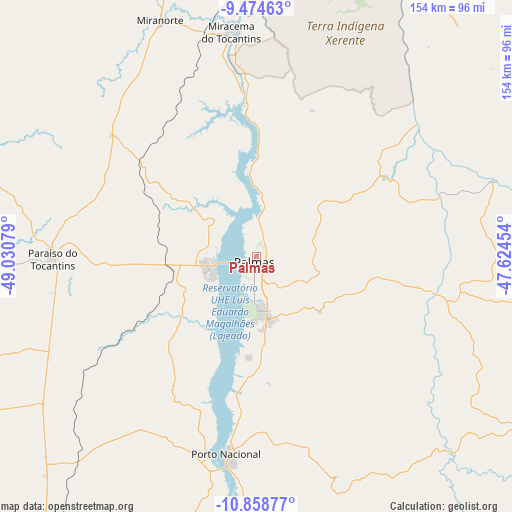
Palmas GPS coordinates[2]
10° 10' 2.82" South, 48° 19' 39.576" West
| Map corner | latitude | longitude |
|---|---|---|
| Upper-left | -9.47463°, | -49.03079° |
| Center: | -10.16745°, | -48.32766° |
| Lower-right: | -10.85877°, | -47.62454° |
| Map W x H: | 153.9×153.9 km | = 95.6×95.6mi |
| max Lat: | 2.81972° ⇑32.5% North |
| Palmas: | -10.16745° |
| min Lat: | ⇓67.5% South -33.69111° |
| min Long | Palmas | max Long |
| -72.89583° | -48.32766° | -32.41083° |
| W 33.8%⇐ | ⇒66.2% E |
Elevation
Elevation of Palmas is 271 m = 889 ft, and this is 109.9 m = 361 ft below average elevation for this country.
| Max E: |
1603 m = 5259 ft | 54.8% |
| Avg. | 380.9 m = 1250 ft | |
| Palmas | 271 m = 889 ft | |
Min E: |
0 m = 0 ft | 45.2% |
See also: Palmas elevation on elevation.city.
Geographical zone
Palmas is located in South Torrid zone (between Equator and Tropic of Capricorn). Distance of Equator is 1130.5 km =702.5 mi to North.| Distance of | km | miles | from Palmas |
|---|---|---|---|
| Equator | 1130.5 | 702.5 | to North |
| Tropic Capricorn | 1475.4 | 916.8 | to South |
| Antarctic Circle | 6270.7 | 3896.4 | to South |
| South Pole | 8876.5 | 5515.6 | to South |


Nearby cities:
15 places around Palmas: (largest is in red/bold)
• Alvorada
271.4 km =168.6 mi,  198°
198°
• Araguaína
331.2 km =205.8 mi,  2°
2°
• Arraias
342.6 km =212.9 mi,  153°
153°
• Campos Belos
361.2 km =224.4 mi, 152°
• Carolina
328.9 km =204.4 mi,  16°
16°
• Conceição do Araguaia
235.5 km =146.3 mi,  333°
333°
• Formosa do Rio Preto
356.3 km =221.4 mi,  105°
105°
• Gilbués
328.8 km =204.3 mi,  83°
83°
• Gurupi
191.6 km =119.1 mi, 204°
• Miracema do Tocantins
67.1 km =41.7 mi,  354°
354°
• Morros
236.1 km =146.7 mi,  70°
70°
• Redenção
302.6 km =188 mi,  321°
321°
• Santa Luzia
306.1 km =190.2 mi, 23°
• Santa Terezinha
241.5 km =150.1 mi,  261°
261°
• Taguatinga
323.1 km =200.8 mi,  140°
140°
Sources, notices
• [Note1] Compared only with cities in Brazil existing in our database
• [Src1] Map data: © OpenStreetMap contributors (CC-BY-SA)
• [Src2] Other city data from geonames.org with taken over terms of usage.
• [Src3] Geographical zone / Annual Mean Temperature by Robert A. Rohde @ Wikipedia
