Redenção geodata
Redenção (Pará) is a populated place; located in Brazil in America/Belem (GMT-3) time zone. With population of 82,464 people, there are 279 cities with bigger population in this country. Compared to other cities in Brazil, 74.8% of cities are located further ↓South; 78.4% of cities are located further →East and 58.8% of cities have higher elevation than Redenção. Note1


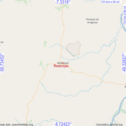
Redenção GPS coordinates[2]
8° 1' 42.996" South, 50° 1' 53.004" West
| Map corner | latitude | longitude |
|---|---|---|
| Upper-left | -7.3318°, | -50.73452° |
| Center: | -8.02861°, | -50.03139° |
| Lower-right: | -8.72423°, | -49.32827° |
| Map W x H: | 154.8×154.8 km | = 96.2×96.2mi |
| max Lat: | 2.81972° ⇑25.2% North |
| Redenção: | -8.02861° |
| min Lat: | ⇓74.8% South -33.69111° |
| min Long | Redenção | max Long |
| -72.89583° | -50.03139° | -32.41083° |
| W 21.6%⇐ | ⇒78.4% E |
Elevation
Elevation of Redenção is 224 m = 735 ft, and this is 156.9 m = 515 ft below average elevation for this country.
| Max E: |
1603 m = 5259 ft | 58.8% |
| Avg. | 380.9 m = 1250 ft | |
| Redenção | 224 m = 735 ft | |
Min E: |
0 m = 0 ft | 41.2% |
See also: Redenção elevation on elevation.city.
Geographical zone
Redenção is located in South Torrid zone (between Equator and Tropic of Capricorn). Distance of Equator is 892.7 km =554.7 mi to North.| Distance of | km | miles | from Redenção |
|---|---|---|---|
| Equator | 892.7 | 554.7 | to North |
| Tropic Capricorn | 1713.2 | 1064.5 | to South |
| Antarctic Circle | 6508.5 | 4044.2 | to South |
| South Pole | 9114.4 | 5663.4 | to South |


Nearby cities:
15 places around Redenção: (largest is in red/bold)
• Araguaína
221.6 km =137.7 mi,  65°
65°
• Carolina
293.4 km =182.3 mi, 74°
• Conceição do Araguaia
87.8 km =54.6 mi,  107°
107°
• Itupiranga
331 km =205.7 mi,  13°
13°
• Marabá
310.6 km =193 mi,  18°
18°
• Miracema do Tocantins
248.5 km =154.4 mi,  133°
133°
• Ourilândia do Norte
183.1 km =113.8 mi,  320°
320°
• Palmas
302.6 km =188 mi,  141°
141°
• Parauapebas
218.5 km =135.8 mi,  3°
3°
• Santa Luzia
312.9 km =194.4 mi,  82°
82°
• Santa Terezinha
276.6 km =171.9 mi,  191°
191°
• São Félix do Xingu
265.6 km =165 mi,  305°
305°
• São Geraldo do Araguaia
243.5 km =151.3 mi,  41°
41°
• Tucumã
189.2 km =117.6 mi, 318°
• Xinguara
103.9 km =64.6 mi, 5°
Sources, notices
• [Note1] Compared only with cities in Brazil existing in our database
• [Src1] Map data: © OpenStreetMap contributors (CC-BY-SA)
• [Src2] Other city data from geonames.org with taken over terms of usage.
• [Src3] Geographical zone / Annual Mean Temperature by Robert A. Rohde @ Wikipedia
