Araguaína geodata
Araguaína (Tocantins) is a populated place; located in Brazil in America/Araguaina (GMT-3) time zone. With population of 105,019 people, there are 219 cities with bigger population in this country. Compared to other cities in Brazil, 79.5% of cities are located further ↓South; 65.7% of cities are located further →East and 57.8% of cities have higher elevation than Araguaína. Note1


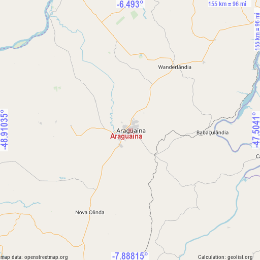
Araguaína GPS coordinates[2]
7° 11' 27.996" South, 48° 12' 25.992" West
| Map corner | latitude | longitude |
|---|---|---|
| Upper-left | -6.493°, | -48.91035° |
| Center: | -7.19111°, | -48.20722° |
| Lower-right: | -7.88815°, | -47.5041° |
| Map W x H: | 155.1×155.1 km | = 96.4×96.4mi |
| max Lat: | 2.81972° ⇑20.5% North |
| Araguaína: | -7.19111° |
| min Lat: | ⇓79.5% South -33.69111° |
| min Long | Araguaína | max Long |
| -72.89583° | -48.20722° | -32.41083° |
| W 34.3%⇐ | ⇒65.7% E |
Elevation
Elevation of Araguaína is 237 m = 778 ft, and this is 143.9 m = 472 ft below average elevation for this country.
| Max E: |
1603 m = 5259 ft | 57.8% |
| Avg. | 380.9 m = 1250 ft | |
| Araguaína | 237 m = 778 ft | |
Min E: |
0 m = 0 ft | 42.2% |
See also: Araguaína elevation on elevation.city.
Geographical zone
Araguaína is located in South Torrid zone (between Equator and Tropic of Capricorn). Distance of Equator is 799.6 km =496.8 mi to North.| Distance of | km | miles | from Araguaína |
|---|---|---|---|
| Equator | 799.6 | 496.8 | to North |
| Tropic Capricorn | 1806.3 | 1122.4 | to South |
| Antarctic Circle | 6601.6 | 4102 | to South |
| South Pole | 9207.5 | 5721.3 | to South |


Nearby cities:
15 places around Araguaína: (largest is in red/bold)
• Amarante do Maranhão
242.5 km =150.7 mi,  41°
41°
• Balsas
242.5 km =150.7 mi,  99°
99°
• Bom Jardim
191.2 km =118.8 mi,  84°
84°
• Carolina
83.7 km =52 mi, 101°
• Conceição do Araguaia
167.2 km =103.9 mi,  224°
224°
• Imperatriz
201.3 km =125.1 mi,  23°
23°
• Marabá
225.7 km =140.2 mi,  333°
333°
• Montes Altos
196.6 km =122.2 mi, 39°
• Parauapebas
225.1 km =139.9 mi,  303°
303°
• Porto Franco
130.2 km =80.9 mi, 43°
• Redenção
221.6 km =137.7 mi,  245°
245°
• Riachão
176.4 km =109.6 mi, 96°
• Santa Luzia
120.1 km =74.6 mi,  114°
114°
• São Geraldo do Araguaia
95.9 km =59.6 mi,  336°
336°
• Xinguara
191.8 km =119.2 mi,  273°
273°
Sources, notices
• [Note1] Compared only with cities in Brazil existing in our database
• [Src1] Map data: © OpenStreetMap contributors (CC-BY-SA)
• [Src2] Other city data from geonames.org with taken over terms of usage.
• [Src3] Geographical zone / Annual Mean Temperature by Robert A. Rohde @ Wikipedia
