Porto Velho geodata
Porto Velho (Rondônia) is a seat of a first-order administrative division; located in Brazil in America/Porto_Velho (GMT-4) time zone. With population of 306,180 people, there are 71 cities with bigger population in this country. Compared to other cities in Brazil, 72% of cities are located further ↓South; 98.3% of cities are located further →East and 73.6% of cities have higher elevation than Porto Velho. Note1


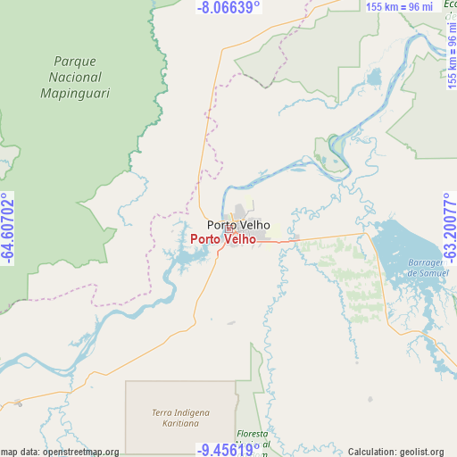
Porto Velho GPS coordinates[2]
8° 45' 42.984" South, 63° 54' 14.004" West
| Map corner | latitude | longitude |
|---|---|---|
| Upper-left | -8.06639°, | -64.60702° |
| Center: | -8.76194°, | -63.90389° |
| Lower-right: | -9.45619°, | -63.20077° |
| Map W x H: | 154.5×154.5 km | = 96×96mi |
| max Lat: | 2.81972° ⇑28% North |
| Porto Velho: | -8.76194° |
| min Lat: | ⇓72% South -33.69111° |
| min Long | Porto Velho | max Long |
| -72.89583° | -63.90389° | -32.41083° |
| W 1.7%⇐ | ⇒98.3% E |
Elevation
Elevation of Porto Velho is 90 m = 295 ft, and this is 290.9 m = 954 ft below average elevation for this country.
| Max E: |
1603 m = 5259 ft | 73.6% |
| Avg. | 380.9 m = 1250 ft | |
| Porto Velho | 90 m = 295 ft | |
Min E: |
0 m = 0 ft | 26.4% |
See also: Porto Velho elevation on elevation.city.
Geographical zone
Porto Velho is located in South Torrid zone (between Equator and Tropic of Capricorn). Distance of Equator is 974.2 km =605.3 mi to North.| Distance of | km | miles | from Porto Velho |
|---|---|---|---|
| Equator | 974.2 | 605.3 | to North |
| Tropic Capricorn | 1631.7 | 1013.9 | to South |
| Antarctic Circle | 6426.9 | 3993.5 | to South |
| South Pole | 9032.8 | 5612.7 | to South |


Nearby cities:
15 places around Porto Velho: (largest is in red/bold)
• Aripuanã
362 km =224.9 mi,  97°
97°
• Ariquemes
159.2 km =98.9 mi,  143°
143°
• Boca do Acre
384 km =238.6 mi,  270°
270°
• Cacoal
401.1 km =249.2 mi, 137°
• Canutama
253.3 km =157.4 mi,  347°
347°
• Extrema
291.5 km =181.1 mi,  247°
247°
• Guajará Mirim
274.1 km =170.3 mi,  214°
214°
• Humaitá
168.5 km =104.7 mi,  34°
34°
• Jaru
244.1 km =151.7 mi, 139°
• Ji Paraná
318.6 km =198 mi, 137°
• Manicoré
436.2 km =271 mi,  41°
41°
• Ouro Preto do Oeste
288.1 km =179 mi, 140°
• Pauini
357.6 km =222.2 mi,  289°
289°
• Plácido de Castro
400.1 km =248.6 mi,  244°
244°
• Presidente Médici
346.5 km =215.3 mi, 140°
Sources, notices
• [Note1] Compared only with cities in Brazil existing in our database
• [Src1] Map data: © OpenStreetMap contributors (CC-BY-SA)
• [Src2] Other city data from geonames.org with taken over terms of usage.
• [Src3] Geographical zone / Annual Mean Temperature by Robert A. Rohde @ Wikipedia
