Nassau geodata
Nassau (New Providence) is a capital of a political entity; located in Bahamas in America/Nassau (GMT-4) time zone. With population of 227,940 people, there are 0 cities with bigger population in this country. Compared to other cities in Bahamas, 50% of cities are located further ↓South; 62.5% of cities are located further →East and 83.3% of cities have higher elevation than Nassau. Note1


Nassau GPS coordinates[2]
25° 3' 29.628" North, 77° 20' 35.016" West
| Map corner | latitude | longitude |
|---|---|---|
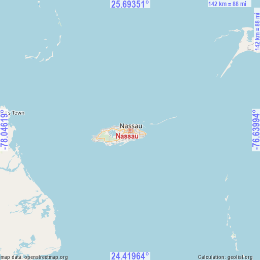
| Upper-left | 25.69351°, | -78.04619° |
| Center: | 25.05823°, | -77.34306° |
| Lower-right: | 24.41964°, | -76.63994° |
| Map W x H: | 141.6×141.6 km | = 88×88mi |
| max Lat: | 26.87137° ⇑50% North |
| Nassau: | 25.05823° |
| min Lat: | ⇓50% South 20.94982° |
| min Long | Nassau | max Long |
| -79.29721° | -77.34306° | -72.96667° |
| W 37.5%⇐ | ⇒62.5% E |
Elevation
Elevation of Nassau is 5 m = 16 ft, and this is 4.5 m = 15 ft below average elevation for this country.
| Max E: |
27 m = 89 ft | 83.3% |
| Avg. | 9.5 m = 31 ft | |
| Nassau | 5 m = 16 ft | |
Min E: |
1 m = 3 ft | 16.7% |
See also: Nassau elevation on elevation.city.
Geographical zone
Nassau is located in North temperate zone (between Tropic of Cancer and the Arctic Circle). Distance of this Northern Tropic circle is 180.3 km =112 mi to South.| Distance of | km | miles | from Nassau |
|---|---|---|---|
| North Pole | 7220.8 | 4486.8 | to North |
| Arctic Circle | 4615 | 2867.6 | to North |
| Tropic Cancer | 180.3 | 112 | to South |
| Equator | 2786.2 | 1731.3 | to South |


Nearby cities:
15 places around Nassau: (largest is in red/bold)
• Alice Town
209.9 km =130.4 mi,  290°
290°
• Andros Town
58.2 km =36.2 mi,  227°
227°
• Arthur’s Town
175.5 km =109.1 mi,  106°
106°
• Black Point
144.1 km =89.5 mi,  137°
137°
• Cooper’s Town
202.3 km =125.7 mi,  355°
355°
• Dunmore Town
86.5 km =53.7 mi,  55°
55°
• Freeport
213 km =132.4 mi,  320°
320°
• George Town
233 km =144.8 mi, 137°
• Governor’s Harbour
112.4 km =69.8 mi,  83°
83°
• Hard Bargain
141.7 km =88 mi,  350°
350°
• High Rock
196.3 km =122 mi,  331°
331°
• Lucaya
210.8 km =131 mi, 321°
• Marsh Harbour
167.3 km =104 mi,  9°
9°
• San Andros
71.2 km =44.2 mi,  270°
270°
• Spanish Wells
79.6 km =49.5 mi,  46°
46°
Sources, notices
• [Note1] Compared only with cities in Bahamas existing in our database
• [Src1] Map data: © OpenStreetMap contributors (CC-BY-SA)
• [Src2] Other city data from geonames.org with taken over terms of usage.
• [Src3] Geographical zone / Annual Mean Temperature by Robert A. Rohde @ Wikipedia
