Cooper’s Town geodata
Cooper’s Town (North Abaco) is a populated place; located in Bahamas in America/Nassau (GMT-4) time zone. With population of 8,413 people, there are 4 cities with bigger population in this country. Compared to other cities in Bahamas, 100% of cities are located further ↓South; 66.7% of cities are located further →East and 95.8% of cities have higher elevation than Cooper’s Town. Note1


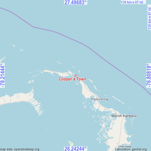
Cooper’s Town GPS coordinates[2]
26° 52' 16.932" North, 77° 30' 40.716" West
| Map corner | latitude | longitude |
|---|---|---|
| Upper-left | 27.49683°, | -78.21444° |
| Center: | 26.87137°, | -77.51131° |
| Lower-right: | 26.24244°, | -76.80819° |
| Map W x H: | 139.5×139.5 km | = 86.7×86.7mi |
| max Lat: | 26.87137° ⇑0% North |
| Cooper’s Town: | 26.87137° |
| min Lat: | ⇓100% South 20.94982° |
| min Long | Cooper’s Town | max Long |
| -79.29721° | -77.51131° | -72.96667° |
| W 33.3%⇐ | ⇒66.7% E |
Elevation
Elevation of Cooper’s Town is 3 m = 10 ft, and this is 6.5 m = 21 ft below average elevation for this country.
| Max E: |
27 m = 89 ft | 95.8% |
| Avg. | 9.5 m = 31 ft | |
| Cooper’s Town | 3 m = 10 ft | |
Min E: |
1 m = 3 ft | 4.2% |
See also: Bahamas elevation on elevation.city.
Geographical zone
Cooper’s Town is located in North temperate zone (between Tropic of Cancer and the Arctic Circle). Distance of this Northern Tropic circle is 381.9 km =237.3 mi to South.| Distance of | km | miles | from Cooper’s Town |
|---|---|---|---|
| North Pole | 7019.2 | 4361.5 | to North |
| Arctic Circle | 4413.4 | 2742.4 | to North |
| Tropic Cancer | 381.9 | 237.3 | to South |
| Equator | 2987.8 | 1856.5 | to South |


Nearby cities:
15 places around Cooper’s Town: (largest is in red/bold)
• Alice Town
218.7 km =135.9 mi,  234°
234°
• Andros Town
242.3 km =150.6 mi,  186°
186°
• Arthur’s Town
310.6 km =193 mi,  143°
143°
• Black Point
328.3 km =204 mi,  159°
159°
• Dunmore Town
175.5 km =109.1 mi,  150°
150°
• Freeport
123.9 km =77 mi,  252°
252°
• Governor’s Harbour
228.5 km =142 mi, 146°
• Hard Bargain
61.9 km =38.5 mi, 185°
• High Rock
81.5 km =50.6 mi, 249°
• Lucaya
120.8 km =75.1 mi, 251°
• Marsh Harbour
57.7 km =35.9 mi,  129°
129°
• Nassau
202.3 km =125.7 mi,  175°
175°
• San Andros
207.8 km =129.1 mi,  195°
195°
• Spanish Wells
165 km =102.5 mi, 153°
• West End
146.9 km =91.3 mi,  261°
261°
Sources, notices
• [Note1] Compared only with cities in Bahamas existing in our database
• [Src1] Map data: © OpenStreetMap contributors (CC-BY-SA)
• [Src2] Other city data from geonames.org with taken over terms of usage.
• [Src3] Geographical zone / Annual Mean Temperature by Robert A. Rohde @ Wikipedia
