Talachyn geodata
Talachyn (Vitebsk) is a seat of a second-order administrative division; located in Belarus in Europe/Minsk (GMT+3) time zone. With population of 11,381 people, there are 72 cities with bigger population in this country. Compared to other cities in Belarus, 82.6% of cities are located further ↓South; 75.3% of cities are located further ←West and 83.6% of cities have lower elevation than Talachyn. Note1


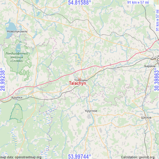
Talachyn GPS coordinates[2]
54° 24' 31.32" North, 29° 41' 43.8" East
| Map corner | latitude | longitude |
|---|---|---|
| Upper-left | 54.81588°, | 28.99238° |
| Center: | 54.4087°, | 29.6955° |
| Lower-right: | 53.99744°, | 30.39863° |
| Map W x H: | 91×91 km | = 56.5×56.5mi |
| max Lat: | 56.0147° ⇑17.4% North |
| Talachyn: | 54.4087° |
| min Lat: | ⇓82.6% South 51.75° |
| min Long | Talachyn | max Long |
| 23.37083° | 29.6955° | 32.578° |
| W 75.3%⇐ | ⇒24.7% E |
Elevation
Elevation of Talachyn is 199 m = 653 ft, and this is 30.4 m = 100 ft above average elevation for this country.
| Max E: |
309 m = 1014 ft | 16.4% |
| Talachyn | 199 m 653 ft | |
| Avg. | 168.6 m = 553 ft | |
Min E: |
108 m = 354 ft | 83.6% |
See also: Belarus elevation on elevation.city.
Geographical zone
Talachyn is located in North temperate zone (between Tropic of Cancer and the Arctic Circle). Distance of this North polar circle is 1351.5 km =839.8 mi to North.| Distance of | km | miles | from Talachyn |
|---|---|---|---|
| North Pole | 3957.4 | 2459 | to North |
| Arctic Circle | 1351.5 | 839.8 | to North |
| Tropic Cancer | 3443.8 | 2139.9 | to South |
| Equator | 6049.7 | 3759.1 | to South |


Nearby cities:
15 places around Talachyn: (largest is in red/bold)
• Balbasava
38.5 km =23.9 mi,  88°
88°
• Baran’
40.9 km =25.4 mi,  79°
79°
• Bobr
28.3 km =17.6 mi,  254°
254°
• Byalynichy
45.5 km =28.3 mi,  178°
178°
• Halowchyn
41.4 km =25.7 mi,  159°
159°
• Kokhanava
20.6 km =12.8 mi,  73°
73°
• Komsyenichy
31.1 km =19.3 mi, 157°
• Konstantinovo
39.2 km =24.4 mi,  315°
315°
• Kopys’
39.7 km =24.7 mi,  104°
104°
• Kruhlaye
18.9 km =11.7 mi, 159°
• Krupki
37.5 km =23.3 mi, 254°
• Novolukoml’
45.1 km =28 mi,  308°
308°
• Shklow
44.1 km =27.4 mi,  119°
119°
• Smolyany
32 km =19.9 mi,  49°
49°
• Syanno
44.7 km =27.8 mi,  1°
1°
Sources, notices
• [Note1] Compared only with cities in Belarus existing in our database
• [Src1] Map data: © OpenStreetMap contributors (CC-BY-SA)
• [Src2] Other city data from geonames.org with taken over terms of usage.
• [Src3] Geographical zone / Annual Mean Temperature by Robert A. Rohde @ Wikipedia
