Krupki geodata
Krupki (Minsk) is a seat of a second-order administrative division; located in Belarus in Europe/Minsk (GMT+3) time zone. With population of 8,600 people, there are 98 cities with bigger population in this country. Compared to other cities in Belarus, 80.9% of cities are located further ↓South; 69.7% of cities are located further ←West and 59.9% of cities have lower elevation than Krupki. Note1


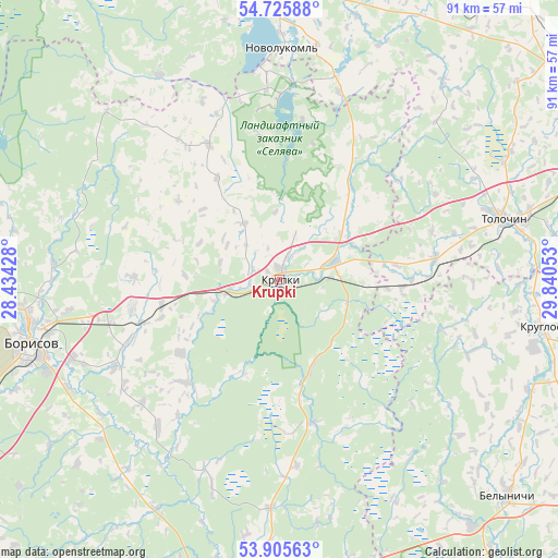
Krupki GPS coordinates[2]
54° 19' 4.08" North, 29° 8' 14.64" East
| Map corner | latitude | longitude |
|---|---|---|
| Upper-left | 54.72588°, | 28.43428° |
| Center: | 54.3178°, | 29.1374° |
| Lower-right: | 53.90563°, | 29.84053° |
| Map W x H: | 91.2×91.2 km | = 56.7×56.7mi |
| max Lat: | 56.0147° ⇑19.1% North |
| Krupki: | 54.3178° |
| min Lat: | ⇓80.9% South 51.75° |
| min Long | Krupki | max Long |
| 23.37083° | 29.1374° | 32.578° |
| W 69.7%⇐ | ⇒30.3% E |
Elevation
Elevation of Krupki is 174 m = 571 ft, and this is 5.4 m = 18 ft above average elevation for this country.
| Max E: |
309 m = 1014 ft | 40.1% |
| Krupki | 174 m 571 ft | |
| Avg. | 168.6 m = 553 ft | |
Min E: |
108 m = 354 ft | 59.9% |
See also: Belarus elevation on elevation.city.
Geographical zone
Krupki is located in North temperate zone (between Tropic of Cancer and the Arctic Circle). Distance of this North polar circle is 1361.6 km =846.1 mi to North.| Distance of | km | miles | from Krupki |
|---|---|---|---|
| North Pole | 3967.5 | 2465.3 | to North |
| Arctic Circle | 1361.6 | 846.1 | to North |
| Tropic Cancer | 3433.7 | 2133.6 | to South |
| Equator | 6039.6 | 3752.8 | to South |


Nearby cities:
15 places around Krupki: (largest is in red/bold)
• Barysaw
42.3 km =26.3 mi,  256°
256°
• Bobr
9.2 km =5.7 mi,  73°
73°
• Byalynichy
51.6 km =32.1 mi,  133°
133°
• Byerazino
54.1 km =33.6 mi,  190°
190°
• Horad Zhodzina
57.7 km =35.9 mi,  245°
245°
• Kholopenichi
25.1 km =15.6 mi,  332°
332°
• Komsyenichy
51.7 km =32.1 mi,  111°
111°
• Konstantinovo
38.9 km =24.2 mi,  12°
12°
• Kruhlaye
43.5 km =27 mi,  100°
100°
• Loshnitsa
24.5 km =15.2 mi, 260°
• Novolukoml’
38.3 km =23.8 mi,  1°
1°
• Pahost
52.2 km =32.4 mi,  179°
179°
• Talachyn
37.5 km =23.3 mi, 74°
• Vyalikaya Mashchanitsa
51.4 km =31.9 mi,  141°
141°
• Zyalyony Bor
54.4 km =33.8 mi,  231°
231°
Sources, notices
• [Note1] Compared only with cities in Belarus existing in our database
• [Src1] Map data: © OpenStreetMap contributors (CC-BY-SA)
• [Src2] Other city data from geonames.org with taken over terms of usage.
• [Src3] Geographical zone / Annual Mean Temperature by Robert A. Rohde @ Wikipedia
