Homyel' geodata
Homyel' (Gomel Oblast) is a seat of a first-order administrative division; located in Belarus in Europe/Minsk (GMT+3) time zone. With population of 480,951 people, there is 1 city with bigger population in this country. Compared to other cities in Belarus, 86.2% of cities are located further ↑North; 94.1% of cities are located further ←West and 87.5% of cities have higher elevation than Homyel'. Note1


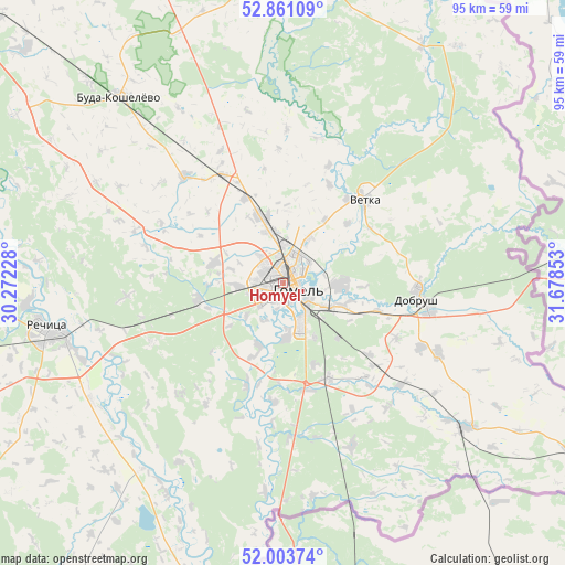
Homyel' GPS coordinates[2]
52° 26' 4.2" North, 30° 58' 31.44" East
| Map corner | latitude | longitude |
|---|---|---|
| Upper-left | 52.86109°, | 30.27228° |
| Center: | 52.4345°, | 30.9754° |
| Lower-right: | 52.00374°, | 31.67853° |
| Map W x H: | 95.3×95.3 km | = 59.2×59.2mi |
| max Lat: | 56.0147° ⇑86.2% North |
| Homyel': | 52.4345° |
| min Lat: | ⇓13.8% South 51.75° |
| min Long | Homyel' | max Long |
| 23.37083° | 30.9754° | 32.578° |
| W 94.1%⇐ | ⇒5.9% E |
Elevation
Elevation of Homyel' is 138 m = 453 ft, and this is 30.6 m = 100 ft below average elevation for this country.
| Max E: |
309 m = 1014 ft | 87.5% |
| Avg. | 168.6 m = 553 ft | |
| Homyel' | 138 m = 453 ft | |
Min E: |
108 m = 354 ft | 12.5% |
See also: Homyel' elevation on elevation.city.
Geographical zone
Homyel' is located in North temperate zone (between Tropic of Cancer and the Arctic Circle). Distance of this North polar circle is 1571 km =976.2 mi to North.| Distance of | km | miles | from Homyel' |
|---|---|---|---|
| North Pole | 4176.9 | 2595.4 | to North |
| Arctic Circle | 1571 | 976.2 | to North |
| Tropic Cancer | 3224.3 | 2003.5 | to South |
| Equator | 5830.2 | 3622.7 | to South |


Nearby cities:
15 places around Homyel': (largest is in red/bold)
• Buda-Kashalyova
41.7 km =25.9 mi,  319°
319°
• Chachersk
53.7 km =33.4 mi,  355°
355°
• Dobrush
23.8 km =14.8 mi,  96°
96°
• Horad Rechytsa
40.2 km =25 mi,  258°
258°
• Karanyowka
13.2 km =8.2 mi,  135°
135°
• Karma
78.2 km =48.6 mi,  351°
351°
• Kastsyukowka
12.2 km =7.6 mi,  341°
341°
• Khal’ch
18.1 km =11.2 mi,  37°
37°
• Loyew
55.7 km =34.6 mi,  192°
192°
• Novaya Huta
36.8 km =22.9 mi,  179°
179°
• Peramoga
7.7 km =4.8 mi,  122°
122°
• Rechytsa
40.4 km =25.1 mi, 258°
• Vasilyevichy
80.5 km =50 mi, 255°
• Vyetka
19.6 km =12.2 mi, 44°
• Zhlobin
81.9 km =50.9 mi,  308°
308°
In other languages:
- In Spanish: Gómel
- In France: Homiel
- In German: Homel
- In Italian: Homel'
- In Russian: Gomel’, Гомель
- In Chinese: 戈梅利
Sources, notices
• [Note1] Compared only with cities in Belarus existing in our database
• [Src1] Map data: © OpenStreetMap contributors (CC-BY-SA)
• [Src2] Other city data from geonames.org with taken over terms of usage.
• [Src3] Geographical zone / Annual Mean Temperature by Robert A. Rohde @ Wikipedia
