Peramoga geodata
Peramoga (Gomel Oblast) is a populated place; located in Belarus in Europe/Minsk (GMT+3) time zone. With population of 1,423 people, there are 215 cities with bigger population in this country. Compared to other cities in Belarus, 87.2% of cities are located further ↑North; 95.4% of cities are located further ←West and 97% of cities have higher elevation than Peramoga. Note1


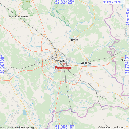
Peramoga GPS coordinates[2]
52° 23' 50.28" North, 31° 4' 15.6" East
| Map corner | latitude | longitude |
|---|---|---|
| Upper-left | 52.82425°, | 30.36788° |
| Center: | 52.3973°, | 31.071° |
| Lower-right: | 51.96618°, | 31.77413° |
| Map W x H: | 95.4×95.4 km | = 59.3×59.3mi |
| max Lat: | 56.0147° ⇑87.2% North |
| Peramoga: | 52.3973° |
| min Lat: | ⇓12.8% South 51.75° |
| min Long | Peramoga | max Long |
| 23.37083° | 31.071° | 32.578° |
| W 95.4%⇐ | ⇒4.6% E |
Elevation
Elevation of Peramoga is 124 m = 407 ft, and this is 44.6 m = 146 ft below average elevation for this country.
| Max E: |
309 m = 1014 ft | 97% |
| Avg. | 168.6 m = 553 ft | |
| Peramoga | 124 m = 407 ft | |
Min E: |
108 m = 354 ft | 3% |
See also: Belarus elevation on elevation.city.
Geographical zone
Peramoga is located in North temperate zone (between Tropic of Cancer and the Arctic Circle). Distance of this North polar circle is 1575.1 km =978.7 mi to North.| Distance of | km | miles | from Peramoga |
|---|---|---|---|
| North Pole | 4181 | 2598 | to North |
| Arctic Circle | 1575.1 | 978.7 | to North |
| Tropic Cancer | 3220.1 | 2000.9 | to South |
| Equator | 5826 | 3620.1 | to South |


Nearby cities:
15 places around Peramoga: (largest is in red/bold)
• Brahin
87.3 km =54.2 mi,  218°
218°
• Buda-Kashalyova
49.2 km =30.6 mi,  316°
316°
• Chachersk
58.6 km =36.4 mi,  349°
349°
• Dobrush
17.2 km =10.7 mi,  85°
85°
• Homyel'
7.7 km =4.8 mi,  302°
302°
• Horad Rechytsa
46.1 km =28.6 mi,  265°
265°
• Karanyowka
5.9 km =3.7 mi,  151°
151°
• Karma
83.5 km =51.9 mi, 347°
• Kastsyukowka
18.9 km =11.7 mi,  326°
326°
• Khal’ch
19.1 km =11.9 mi,  13°
13°
• Loyew
53.6 km =33.3 mi,  200°
200°
• Novaya Huta
33.2 km =20.6 mi,  190°
190°
• Rechytsa
46.3 km =28.8 mi, 265°
• Vasilyevichy
86 km =53.4 mi,  259°
259°
• Vyetka
19.4 km =12.1 mi,  22°
22°
Sources, notices
• [Note1] Compared only with cities in Belarus existing in our database
• [Src1] Map data: © OpenStreetMap contributors (CC-BY-SA)
• [Src2] Other city data from geonames.org with taken over terms of usage.
• [Src3] Geographical zone / Annual Mean Temperature by Robert A. Rohde @ Wikipedia
