Buda-Kashalyova geodata
Buda-Kashalyova (Gomel Oblast) is a seat of a second-order administrative division; located in Belarus in Europe/Minsk (GMT+3) time zone. In our database, there are 292 cities with bigger population. Compared to other cities in Belarus, 81.2% of cities are located further ↑North; 90.1% of cities are located further ←West and 73% of cities have higher elevation than Buda-Kashalyova. Note1


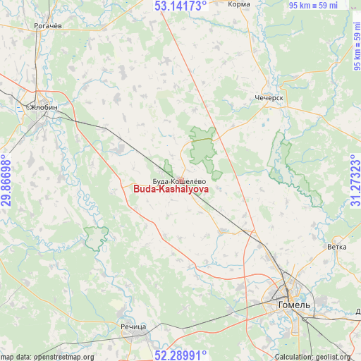
Buda-Kashalyova GPS coordinates[2]
52° 43' 4.44" North, 30° 34' 12.36" East
| Map corner | latitude | longitude |
|---|---|---|
| Upper-left | 53.14173°, | 29.86698° |
| Center: | 52.7179°, | 30.5701° |
| Lower-right: | 52.28991°, | 31.27323° |
| Map W x H: | 94.7×94.7 km | = 58.8×58.8mi |
| max Lat: | 56.0147° ⇑81.2% North |
| Buda-Kashalyova: | 52.7179° |
| min Lat: | ⇓18.8% South 51.75° |
| min Long | Buda-Kashalyova | max Long |
| 23.37083° | 30.5701° | 32.578° |
| W 90.1%⇐ | ⇒9.9% E |
Elevation
Elevation of Buda-Kashalyova is 147 m = 482 ft, and this is 21.6 m = 71 ft below average elevation for this country.
| Max E: |
309 m = 1014 ft | 73% |
| Avg. | 168.6 m = 553 ft | |
| Buda-Kashalyova | 147 m = 482 ft | |
Min E: |
108 m = 354 ft | 27% |
See also: Belarus elevation on elevation.city.
Geographical zone
Buda-Kashalyova is located in North temperate zone (between Tropic of Cancer and the Arctic Circle). Distance of this North polar circle is 1539.5 km =956.6 mi to North.| Distance of | km | miles | from Buda-Kashalyova |
|---|---|---|---|
| North Pole | 4145.4 | 2575.8 | to North |
| Arctic Circle | 1539.5 | 956.6 | to North |
| Tropic Cancer | 3255.8 | 2023.1 | to South |
| Equator | 5861.7 | 3642.3 | to South |


Nearby cities:
15 places around Buda-Kashalyova: (largest is in red/bold)
• Chachersk
32.1 km =19.9 mi,  46°
46°
• Dobrush
61.4 km =38.2 mi,  124°
124°
• Dowsk
49.4 km =30.7 mi,  351°
351°
• Homyel'
41.7 km =25.9 mi,  139°
139°
• Horad Rechytsa
41.1 km =25.5 mi,  196°
196°
• Karanyowka
54.9 km =34.1 mi, 138°
• Karma
48.4 km =30.1 mi,  18°
18°
• Kastsyukowka
30.8 km =19.1 mi,  130°
130°
• Khal’ch
41.9 km =26 mi,  114°
114°
• Peramoga
49.2 km =30.6 mi, 136°
• Rahachow
54.4 km =33.8 mi,  320°
320°
• Rechytsa
41.4 km =25.7 mi, 196°
• Svyetlahorsk
56.8 km =35.3 mi,  260°
260°
• Vyetka
44.7 km =27.8 mi, 113°
• Zhlobin
41.5 km =25.8 mi,  297°
297°
In other languages:
- In France: Bouda-Kachaliova
- In Russian: Буда-Кошелево, Буда-Кошелёво
- In Chinese: 布達卡沙廖瓦
Sources, notices
• [Note1] Compared only with cities in Belarus existing in our database
• [Src1] Map data: © OpenStreetMap contributors (CC-BY-SA)
• [Src2] Other city data from geonames.org with taken over terms of usage.
• [Src3] Geographical zone / Annual Mean Temperature by Robert A. Rohde @ Wikipedia
