Kholopenichi geodata
Kholopenichi (Minsk) is a populated place; located in Belarus in Europe/Minsk (GMT+3) time zone. With population of 1,385 people, there are 218 cities with bigger population in this country. Compared to other cities in Belarus, 86.8% of cities are located further ↓South; 68.8% of cities are located further ←West and 78% of cities have lower elevation than Kholopenichi. Note1


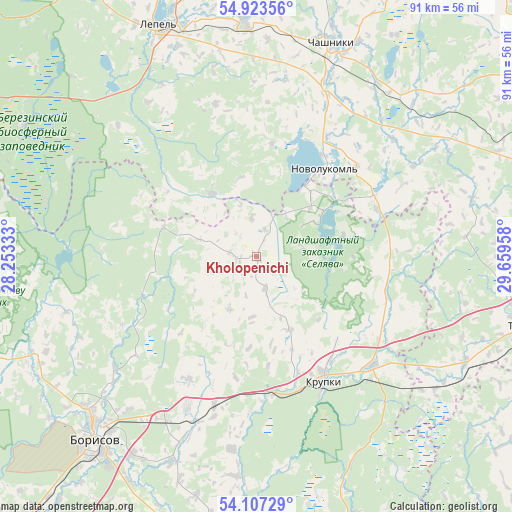
Kholopenichi GPS coordinates[2]
54° 31' 2.856" North, 28° 57' 23.22" East
| Map corner | latitude | longitude |
|---|---|---|
| Upper-left | 54.92356°, | 28.25333° |
| Center: | 54.51746°, | 28.95645° |
| Lower-right: | 54.10729°, | 29.65958° |
| Map W x H: | 90.8×90.8 km | = 56.4×56.4mi |
| max Lat: | 56.0147° ⇑13.2% North |
| Kholopenichi: | 54.51746° |
| min Lat: | ⇓86.8% South 51.75° |
| min Long | Kholopenichi | max Long |
| 23.37083° | 28.95645° | 32.578° |
| W 68.8%⇐ | ⇒31.2% E |
Elevation
Elevation of Kholopenichi is 190 m = 623 ft, and this is 21.4 m = 70 ft above average elevation for this country.
| Max E: |
309 m = 1014 ft | 22% |
| Kholopenichi | 190 m 623 ft | |
| Avg. | 168.6 m = 553 ft | |
Min E: |
108 m = 354 ft | 78% |
See also: Belarus elevation on elevation.city.
Geographical zone
Kholopenichi is located in North temperate zone (between Tropic of Cancer and the Arctic Circle). Distance of this North polar circle is 1339.4 km =832.3 mi to North.| Distance of | km | miles | from Kholopenichi |
|---|---|---|---|
| North Pole | 3945.3 | 2451.5 | to North |
| Arctic Circle | 1339.4 | 832.3 | to North |
| Tropic Cancer | 3455.9 | 2147.4 | to South |
| Equator | 6061.8 | 3766.6 | to South |


Nearby cities:
15 places around Kholopenichi: (largest is in red/bold)
• Barysaw
43.5 km =27 mi,  222°
222°
• Bobr
28.3 km =17.6 mi,  133°
133°
• Byahoml’
62.6 km =38.9 mi,  292°
292°
• Chashniki
40.1 km =24.9 mi,  19°
19°
• Horad Zhodzina
61.7 km =38.3 mi, 220°
• Konstantinovo
25.5 km =15.8 mi,  51°
51°
• Kruhlaye
62 km =38.5 mi,  118°
118°
• Krupki
25.1 km =15.6 mi,  152°
152°
• Loshnitsa
29.2 km =18.1 mi,  205°
205°
• Lyepyel’
43.7 km =27.2 mi,  337°
337°
• Novolukoml’
20.3 km =12.6 mi,  37°
37°
• Syanno
58.3 km =36.2 mi,  56°
56°
• Talachyn
49.3 km =30.6 mi,  104°
104°
• Zyalyony Bor
64 km =39.8 mi, 208°
• Zyembin
50.8 km =31.6 mi,  249°
249°
Sources, notices
• [Note1] Compared only with cities in Belarus existing in our database
• [Src1] Map data: © OpenStreetMap contributors (CC-BY-SA)
• [Src2] Other city data from geonames.org with taken over terms of usage.
• [Src3] Geographical zone / Annual Mean Temperature by Robert A. Rohde @ Wikipedia
