Zhlobin geodata
Zhlobin (Gomel Oblast) is a seat of a second-order administrative division; located in Belarus in Europe/Minsk (GMT+3) time zone. With population of 73,089 people, there are 17 cities with bigger population in this country. Compared to other cities in Belarus, 78% of cities are located further ↑North; 79.3% of cities are located further ←West and 85.9% of cities have higher elevation than Zhlobin. Note1


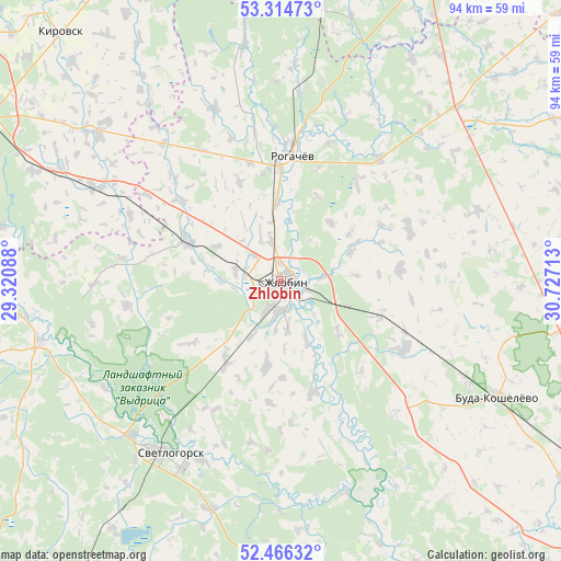
Zhlobin GPS coordinates[2]
52° 53' 33.36" North, 30° 1' 26.4" East
| Map corner | latitude | longitude |
|---|---|---|
| Upper-left | 53.31473°, | 29.32088° |
| Center: | 52.8926°, | 30.024° |
| Lower-right: | 52.46632°, | 30.72713° |
| Map W x H: | 94.3×94.3 km | = 58.6×58.6mi |
| max Lat: | 56.0147° ⇑78% North |
| Zhlobin: | 52.8926° |
| min Lat: | ⇓22% South 51.75° |
| min Long | Zhlobin | max Long |
| 23.37083° | 30.024° | 32.578° |
| W 79.3%⇐ | ⇒20.7% E |
Elevation
Elevation of Zhlobin is 139 m = 456 ft, and this is 29.6 m = 97 ft below average elevation for this country.
| Max E: |
309 m = 1014 ft | 85.9% |
| Avg. | 168.6 m = 553 ft | |
| Zhlobin | 139 m = 456 ft | |
Min E: |
108 m = 354 ft | 14.1% |
See also: Zhlobin elevation on elevation.city.
Geographical zone
Zhlobin is located in North temperate zone (between Tropic of Cancer and the Arctic Circle). Distance of this North polar circle is 1520.1 km =944.5 mi to North.| Distance of | km | miles | from Zhlobin |
|---|---|---|---|
| North Pole | 4126 | 2563.8 | to North |
| Arctic Circle | 1520.1 | 944.5 | to North |
| Tropic Cancer | 3275.2 | 2035.1 | to South |
| Equator | 5881.1 | 3654.3 | to South |


Nearby cities:
15 places around Zhlobin: (largest is in red/bold)
• Babruysk
60.2 km =37.4 mi,  296°
296°
• Buda-Kashalyova
41.5 km =25.8 mi,  117°
117°
• Bykhaw
71.4 km =44.4 mi,  11°
11°
• Chachersk
60 km =37.3 mi,  87°
87°
• Dowsk
41.4 km =25.7 mi,  44°
44°
• Horad Rechytsa
63.9 km =39.7 mi,  156°
156°
• Karma
58.3 km =36.2 mi,  63°
63°
• Kirawsk
55.7 km =34.6 mi,  318°
318°
• Krasnyy Bereg
49.8 km =30.9 mi, 13°
• Myshkavichy
49.7 km =30.9 mi, 316°
• Parychy
41.9 km =26 mi,  256°
256°
• Rahachow
22.4 km =13.9 mi,  4°
4°
• Rechytsa
64 km =39.8 mi, 157°
• Sasnovy Bor
50.4 km =31.3 mi,  214°
214°
• Svyetlahorsk
34.7 km =21.6 mi, 213°
Sources, notices
• [Note1] Compared only with cities in Belarus existing in our database
• [Src1] Map data: © OpenStreetMap contributors (CC-BY-SA)
• [Src2] Other city data from geonames.org with taken over terms of usage.
• [Src3] Geographical zone / Annual Mean Temperature by Robert A. Rohde @ Wikipedia
