Dangriga geodata
Dangriga (Stann Creek) is a seat of a first-order administrative division; located in Belize in America/Belize (GMT-6) time zone. With population of 10,750 people, there are 4 cities with bigger population in this country. Compared to other cities in Belize, 81.8% of cities are located further ↑North; 81.8% of cities are located further ←West and 72.7% of cities have higher elevation than Dangriga. Note1


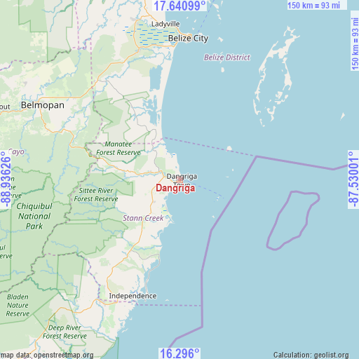
Dangriga GPS coordinates[2]
16° 58' 10.92" North, 88° 13' 59.268" West
| Map corner | latitude | longitude |
|---|---|---|
| Upper-left | 17.64099°, | -88.93626° |
| Center: | 16.9697°, | -88.23313° |
| Lower-right: | 16.296°, | -87.53001° |
| Map W x H: | 149.5×149.6 km | = 92.9×93mi |
| max Lat: | 18.39375° ⇑81.8% North |
| Dangriga: | 16.9697° |
| min Lat: | ⇓18.2% South 16.09835° |
| min Long | Dangriga | max Long |
| -89.13917° | -88.23313° | -87.9659° |
| W 81.8%⇐ | ⇒18.2% E |
Elevation
Elevation of Dangriga is 7 m = 23 ft, and this is 24.4 m = 80 ft below average elevation for this country.
| Max E: |
89 m = 292 ft | 72.7% |
| Avg. | 31.4 m = 103 ft | |
| Dangriga | 7 m = 23 ft | |
Min E: |
4 m = 13 ft | 27.3% |
See also: Belize elevation on elevation.city.
Geographical zone
Dangriga is located in North Torrid zone (between Equator and Tropic of Cancer). Distance of this Northern Tropic circle is 719.1 km =446.8 mi to North.| Distance of | km | miles | from Dangriga |
|---|---|---|---|
| North Pole | 8120.2 | 5045.7 | to North |
| Arctic Circle | 5514.3 | 3426.4 | to North |
| Tropic Cancer | 719.1 | 446.8 | to North |
| Equator | 1886.9 | 1172.5 | to South |


Nearby cities:
11 places around Dangriga: (largest is in red/bold)
• Belize City
59 km =36.7 mi,  3°
3°
• Belmopan
64.7 km =40.2 mi,  298°
298°
• Benque Viejo el Carmen
97 km =60.3 mi,  276°
276°
• Corozal
159.2 km =98.9 mi,  354°
354°
• Orange Walk
128.5 km =79.8 mi,  344°
344°
• Placencia
52.6 km =32.7 mi,  195°
195°
• Punta Gorda
114.7 km =71.3 mi,  212°
212°
• San Ignacio
91.4 km =56.8 mi, 283°
• San Pedro
109 km =67.7 mi,  15°
15°
• Shipyard
112.1 km =69.7 mi, 336°
• Valley of Peace
75.7 km =47 mi, 302°
Sources, notices
• [Note1] Compared only with cities in Belize existing in our database
• [Src1] Map data: © OpenStreetMap contributors (CC-BY-SA)
• [Src2] Other city data from geonames.org with taken over terms of usage.
• [Src3] Geographical zone / Annual Mean Temperature by Robert A. Rohde @ Wikipedia
