Corozal geodata
Corozal is a seat of a first-order administrative division; located in Belize in America/Belize (GMT-6) time zone. With population of 9,871 people, there are 5 cities with bigger population in this country. Compared to other cities in Belize, 100% of cities are located further ↓South; 63.6% of cities are located further ←West and 90.9% of cities have higher elevation than Corozal. Note1


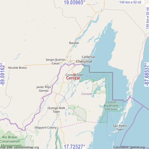
Corozal GPS coordinates[2]
18° 23' 37.5" North, 88° 23' 18.564" West
| Map corner | latitude | longitude |
|---|---|---|
| Upper-left | 19.05965°, | -89.09162° |
| Center: | 18.39375°, | -88.38849° |
| Lower-right: | 17.72527°, | -87.68537° |
| Map W x H: | 148.4×148.4 km | = 92.2×92.2mi |
| max Lat: | 18.39375° ⇑0% North |
| Corozal: | 18.39375° |
| min Lat: | ⇓100% South 16.09835° |
| min Long | Corozal | max Long |
| -89.13917° | -88.38849° | -87.9659° |
| W 63.6%⇐ | ⇒36.4% E |
Elevation
Elevation of Corozal is 5 m = 16 ft, and this is 26.4 m = 87 ft below average elevation for this country.
| Max E: |
89 m = 292 ft | 90.9% |
| Avg. | 31.4 m = 103 ft | |
| Corozal | 5 m = 16 ft | |
Min E: |
4 m = 13 ft | 9.1% |
See also: Belize elevation on elevation.city.
Geographical zone
Corozal is located in North Torrid zone (between Equator and Tropic of Cancer). Distance of this Northern Tropic circle is 560.7 km =348.4 mi to North.| Distance of | km | miles | from Corozal |
|---|---|---|---|
| North Pole | 7961.9 | 4947.3 | to North |
| Arctic Circle | 5356 | 3328.1 | to North |
| Tropic Cancer | 560.7 | 348.4 | to North |
| Equator | 2045.2 | 1270.8 | to South |


Nearby cities:
11 places around Corozal: (largest is in red/bold)
• Belize City
101.5 km =63.1 mi,  168°
168°
• Belmopan
133.3 km =82.8 mi,  197°
197°
• Benque Viejo el Carmen
166.8 km =103.6 mi,  208°
208°
• Dangriga
159.2 km =98.9 mi, 174°
• Orange Walk
39.3 km =24.4 mi, 207°
• Placencia
209 km =129.9 mi,  179°
179°
• Punta Gorda
259.1 km =161 mi,  189°
189°
• San Ignacio
155.1 km =96.4 mi, 207°
• San Pedro
69.4 km =43.1 mi,  139°
139°
• Shipyard
62.3 km =38.7 mi, 206°
• Valley of Peace
126.9 km =78.9 mi, 201°
Sources, notices
• [Note1] Compared only with cities in Belize existing in our database
• [Src1] Map data: © OpenStreetMap contributors (CC-BY-SA)
• [Src2] Other city data from geonames.org with taken over terms of usage.
• [Src3] Geographical zone / Annual Mean Temperature by Robert A. Rohde @ Wikipedia
