Valley of Peace geodata
Valley of Peace (Cayo) is a populated place; located in Belize in America/Belize (GMT-6) time zone. With population of 1,809 people, there are 11 cities with bigger population in this country. Compared to other cities in Belize, 54.5% of cities are located further ↓South; 81.8% of cities are located further →East and 90.9% of cities have lower elevation than Valley of Peace. Note1


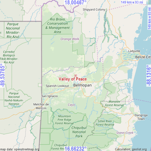
Valley of Peace GPS coordinates[2]
17° 20' 4.992" North, 88° 50' 4.992" West
| Map corner | latitude | longitude |
|---|---|---|
| Upper-left | 18.00467°, | -89.53785° |
| Center: | 17.33472°, | -88.83472° |
| Lower-right: | 16.66232°, | -88.1316° |
| Map W x H: | 149.3×149.3 km | = 92.8×92.8mi |
| max Lat: | 18.39375° ⇑45.5% North |
| Valley of Peace: | 17.33472° |
| min Lat: | ⇓54.5% South 16.09835° |
| min Long | Valley of Peace | max Long |
| -89.13917° | -88.83472° | -87.9659° |
| W 18.2%⇐ | ⇒81.8% E |
Elevation
Elevation of Valley of Peace is 80 m = 262 ft, and this is 48.6 m = 159 ft above average elevation for this country.
| Max E: |
89 m = 292 ft | 9.1% |
| Valley of Peace | 80 m 262 ft | |
| Avg. | 31.4 m = 103 ft | |
Min E: |
4 m = 13 ft | 90.9% |
See also: Belize elevation on elevation.city.
Geographical zone
Valley of Peace is located in North Torrid zone (between Equator and Tropic of Cancer). Distance of this Northern Tropic circle is 678.5 km =421.6 mi to North.| Distance of | km | miles | from Valley of Peace |
|---|---|---|---|
| North Pole | 8079.6 | 5020.4 | to North |
| Arctic Circle | 5473.7 | 3401.2 | to North |
| Tropic Cancer | 678.5 | 421.6 | to North |
| Equator | 1927.4 | 1197.6 | to South |


Nearby cities:
11 places around Valley of Peace: (largest is in red/bold)
• Belize City
70 km =43.5 mi,  74°
74°
• Belmopan
11.9 km =7.4 mi,  142°
142°
• Benque Viejo el Carmen
43.4 km =27 mi,  228°
228°
• Corozal
126.9 km =78.9 mi,  21°
21°
• Dangriga
75.7 km =47 mi,  122°
122°
• Orange Walk
87.8 km =54.6 mi, 19°
• Placencia
103.9 km =64.6 mi,  151°
151°
• Punta Gorda
137.5 km =85.4 mi,  178°
178°
• San Ignacio
31.7 km =19.7 mi, 231°
• San Pedro
112.5 km =69.9 mi,  54°
54°
• Shipyard
65 km =40.4 mi, 17°
Sources, notices
• [Note1] Compared only with cities in Belize existing in our database
• [Src1] Map data: © OpenStreetMap contributors (CC-BY-SA)
• [Src2] Other city data from geonames.org with taken over terms of usage.
• [Src3] Geographical zone / Annual Mean Temperature by Robert A. Rohde @ Wikipedia
