Belize City geodata
Belize City (Belize) is a seat of a first-order administrative division; located in Belize in America/Belize (GMT-6) time zone. With population of 61,461 people, there are 0 cities with bigger population in this country. Compared to other cities in Belize, 63.6% of cities are located further ↓South; 90.9% of cities are located further ←West and 81.8% of cities have higher elevation than Belize City. Note1


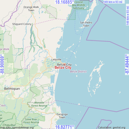
Belize City GPS coordinates[2]
17° 29' 58.272" North, 88° 11' 51.216" West
| Map corner | latitude | longitude |
|---|---|---|
| Upper-left | 18.16885°, | -88.90069° |
| Center: | 17.49952°, | -88.19756° |
| Lower-right: | 16.82771°, | -87.49444° |
| Map W x H: | 149.1×149.1 km | = 92.6×92.6mi |
| max Lat: | 18.39375° ⇑36.4% North |
| Belize City: | 17.49952° |
| min Lat: | ⇓63.6% South 16.09835° |
| min Long | Belize City | max Long |
| -89.13917° | -88.19756° | -87.9659° |
| W 90.9%⇐ | ⇒9.1% E |
Elevation
Elevation of Belize City is 6 m = 20 ft, and this is 25.4 m = 83 ft below average elevation for this country.
| Max E: |
89 m = 292 ft | 81.8% |
| Avg. | 31.4 m = 103 ft | |
| Belize City | 6 m = 20 ft | |
Min E: |
4 m = 13 ft | 18.2% |
See also: Belize City elevation on elevation.city.
Geographical zone
Belize City is located in North Torrid zone (between Equator and Tropic of Cancer). Distance of this Northern Tropic circle is 660.2 km =410.2 mi to North.| Distance of | km | miles | from Belize City |
|---|---|---|---|
| North Pole | 8061.3 | 5009.1 | to North |
| Arctic Circle | 5455.4 | 3389.8 | to North |
| Tropic Cancer | 660.2 | 410.2 | to North |
| Equator | 1945.8 | 1209.1 | to South |


Nearby cities:
11 places around Belize City: (largest is in red/bold)
• Belmopan
66.5 km =41.3 mi,  245°
245°
• Benque Viejo el Carmen
110.6 km =68.7 mi,  244°
244°
• Corozal
101.5 km =63.1 mi,  348°
348°
• Dangriga
59 km =36.7 mi,  183°
183°
• Orange Walk
75.4 km =46.9 mi,  329°
329°
• Placencia
111 km =69 mi,  189°
189°
• Punta Gorda
168.9 km =104.9 mi,  202°
202°
• San Ignacio
100 km =62.1 mi, 247°
• San Pedro
52.4 km =32.6 mi,  27°
27°
• Shipyard
65.3 km =40.6 mi,  312°
312°
• Valley of Peace
70 km =43.5 mi, 254°
Sources, notices
• [Note1] Compared only with cities in Belize existing in our database
• [Src1] Map data: © OpenStreetMap contributors (CC-BY-SA)
• [Src2] Other city data from geonames.org with taken over terms of usage.
• [Src3] Geographical zone / Annual Mean Temperature by Robert A. Rohde @ Wikipedia
