Albanel geodata
Albanel (Quebec) is a populated place; located in Canada in America/Toronto (GMT-4) time zone. With population of 1,087 people, there are 1008 cities with bigger population in this country. Compared to other cities in Canada, 61.1% of cities are located further ↓South; 75.1% of cities are located further ←West and 53.5% of cities have higher elevation than Albanel. Note1


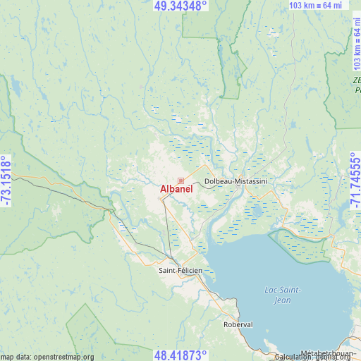
Albanel GPS coordinates[2]
48° 52' 59.664" North, 72° 26' 55.212" West
| Map corner | latitude | longitude |
|---|---|---|
| Upper-left | 49.34348°, | -73.1518° |
| Center: | 48.88324°, | -72.44867° |
| Lower-right: | 48.41873°, | -71.74555° |
| Map W x H: | 102.8×102.8 km | = 63.9×63.9mi |
| max Lat: | 73.03752° ⇑38.9% North |
| Albanel: | 48.88324° |
| min Lat: | ⇓61.1% South 42.05009° |
| min Long | Albanel | max Long |
| -139.43328° | -72.44867° | -52.70931° |
| W 75.1%⇐ | ⇒24.9% E |
Elevation
Elevation of Albanel is 150 m = 492 ft, and this is 104.4 m = 343 ft below average elevation for this country.
| Max E: |
1518 m = 4980 ft | 53.5% |
| Avg. | 254.4 m = 835 ft | |
| Albanel | 150 m = 492 ft | |
Min E: |
-2 m = -7 ft | 46.5% |
See also: Canada elevation on elevation.city.
Geographical zone
Albanel is located in North temperate zone (between Tropic of Cancer and the Arctic Circle). Distance of this North polar circle is 1965.9 km =1221.6 mi to North.| Distance of | km | miles | from Albanel |
|---|---|---|---|
| North Pole | 4571.8 | 2840.8 | to North |
| Arctic Circle | 1965.9 | 1221.6 | to North |
| Tropic Cancer | 2829.4 | 1758.1 | to South |
| Equator | 5435.3 | 3377.3 | to South |


Nearby cities:
15 places around Albanel: (largest is in red/bold)
• Alma
69.4 km =43.1 mi,  122°
122°
• Chambord
57.4 km =35.7 mi,  150°
150°
• Dolbeau-Mistassini
15.9 km =9.9 mi,  91°
91°
• L'Ascension-de-Notre-Seigneur
61.5 km =38.2 mi,  111°
111°
• Metabetchouan-Lac-a-la-Croix
72 km =44.7 mi,  136°
136°
• Métabetchouan
65.6 km =40.8 mi, 151°
• Normandin
8.3 km =5.2 mi,  227°
227°
• Pointe-du-Lac
64.9 km =40.3 mi,  131°
131°
• Pont Rouge
26.8 km =16.7 mi, 89°
• Roberval
43.7 km =27.2 mi,  158°
158°
• Saint-Bruno
74.8 km =46.5 mi, 128°
• Saint-Félicien
25.9 km =16.1 mi,  180°
180°
• Saint-Gédéon
65.8 km =40.9 mi, 130°
• Saint-Nazaire
73.4 km =45.6 mi, 116°
• Saint-Prime
34.4 km =21.4 mi,  165°
165°
Sources, notices
• [Note1] Compared only with cities in Canada existing in our database
• [Src1] Map data: © OpenStreetMap contributors (CC-BY-SA)
• [Src2] Other city data from geonames.org with taken over terms of usage.
• [Src3] Geographical zone / Annual Mean Temperature by Robert A. Rohde @ Wikipedia
