Alma geodata
Alma (Quebec) is a populated place; located in Canada in America/Toronto (GMT-4) time zone. With population of 29,526 people, there are 149 cities with bigger population in this country. Compared to other cities in Canada, 58.4% of cities are located further ↓South; 78.5% of cities are located further ←West and 62.1% of cities have higher elevation than Alma. Note1


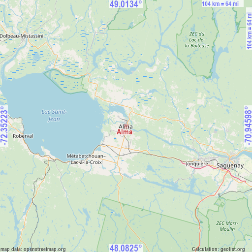
Alma GPS coordinates[2]
48° 33' 0.324" North, 71° 38' 56.76" West
| Map corner | latitude | longitude |
|---|---|---|
| Upper-left | 49.0134°, | -72.35223° |
| Center: | 48.55009°, | -71.6491° |
| Lower-right: | 48.0825°, | -70.94598° |
| Map W x H: | 103.5×103.5 km | = 64.3×64.3mi |
| max Lat: | 73.03752° ⇑41.6% North |
| Alma: | 48.55009° |
| min Lat: | ⇓58.4% South 42.05009° |
| min Long | Alma | max Long |
| -139.43328° | -71.6491° | -52.70931° |
| W 78.5%⇐ | ⇒21.5% E |
Elevation
Elevation of Alma is 90 m = 295 ft, and this is 164.4 m = 539 ft below average elevation for this country.
| Max E: |
1518 m = 4980 ft | 62.1% |
| Avg. | 254.4 m = 835 ft | |
| Alma | 90 m = 295 ft | |
Min E: |
-2 m = -7 ft | 37.9% |
See also: Canada elevation on elevation.city.
Geographical zone
Alma is located in North temperate zone (between Tropic of Cancer and the Arctic Circle). Distance of this North polar circle is 2002.9 km =1244.5 mi to North.| Distance of | km | miles | from Alma |
|---|---|---|---|
| North Pole | 4608.8 | 2863.8 | to North |
| Arctic Circle | 2002.9 | 1244.5 | to North |
| Tropic Cancer | 2792.3 | 1735.1 | to South |
| Equator | 5398.3 | 3354.3 | to South |


Nearby cities:
15 places around Alma: (largest is in red/bold)
• Chambord
33.3 km =20.7 mi,  247°
247°
• Jonquière
33 km =20.5 mi,  116°
116°
• L'Ascension-de-Notre-Seigneur
14.9 km =9.3 mi,  355°
355°
• Metabetchouan-Lac-a-la-Croix
18.3 km =11.4 mi,  211°
211°
• Métabetchouan
33.9 km =21.1 mi,  232°
232°
• Pointe-du-Lac
11.3 km =7 mi,  240°
240°
• Pont Rouge
48.8 km =30.3 mi,  319°
319°
• Roberval
43.1 km =26.8 mi,  265°
265°
• Saguenay
45.5 km =28.3 mi,  109°
109°
• Saint-Ambroise
23.3 km =14.5 mi,  90°
90°
• Saint-Bruno
9.3 km =5.8 mi,  180°
180°
• Saint-Charles-de-Bourget
20.9 km =13 mi,  84°
84°
• Saint-Gédéon
10.2 km =6.3 mi, 237°
• Saint-Honoré
41.8 km =26 mi, 92°
• Saint-Nazaire
8.3 km =5.2 mi,  58°
58°
Sources, notices
• [Note1] Compared only with cities in Canada existing in our database
• [Src1] Map data: © OpenStreetMap contributors (CC-BY-SA)
• [Src2] Other city data from geonames.org with taken over terms of usage.
• [Src3] Geographical zone / Annual Mean Temperature by Robert A. Rohde @ Wikipedia
