Roberval geodata
Roberval (Quebec) is a populated place; located in Canada in America/Toronto (GMT-4) time zone. With population of 9,287 people, there are 331 cities with bigger population in this country. Compared to other cities in Canada, 58.1% of cities are located further ↓South; 75.7% of cities are located further ←West and 58.1% of cities have higher elevation than Roberval. Note1


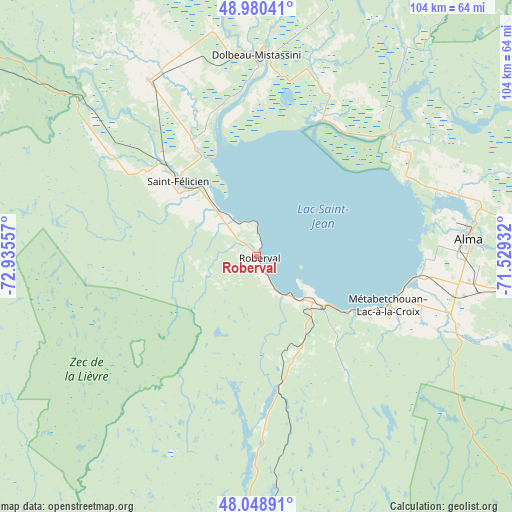
Roberval GPS coordinates[2]
48° 31' 0.48" North, 72° 13' 56.784" West
| Map corner | latitude | longitude |
|---|---|---|
| Upper-left | 48.98041°, | -72.93557° |
| Center: | 48.5168°, | -72.23244° |
| Lower-right: | 48.04891°, | -71.52932° |
| Map W x H: | 103.6×103.6 km | = 64.4×64.4mi |
| max Lat: | 73.03752° ⇑41.9% North |
| Roberval: | 48.5168° |
| min Lat: | ⇓58.1% South 42.05009° |
| min Long | Roberval | max Long |
| -139.43328° | -72.23244° | -52.70931° |
| W 75.7%⇐ | ⇒24.3% E |
Elevation
Elevation of Roberval is 113 m = 371 ft, and this is 141.4 m = 464 ft below average elevation for this country.
| Max E: |
1518 m = 4980 ft | 58.1% |
| Avg. | 254.4 m = 835 ft | |
| Roberval | 113 m = 371 ft | |
Min E: |
-2 m = -7 ft | 41.9% |
See also: Canada elevation on elevation.city.
Geographical zone
Roberval is located in North temperate zone (between Tropic of Cancer and the Arctic Circle). Distance of this North polar circle is 2006.6 km =1246.8 mi to North.| Distance of | km | miles | from Roberval |
|---|---|---|---|
| North Pole | 4612.5 | 2866.1 | to North |
| Arctic Circle | 2006.6 | 1246.8 | to North |
| Tropic Cancer | 2788.6 | 1732.8 | to South |
| Equator | 5394.6 | 3352 | to South |


Nearby cities:
15 places around Roberval: (largest is in red/bold)
• Albanel
43.7 km =27.2 mi,  338°
338°
• Alma
43.1 km =26.8 mi,  85°
85°
• Chambord
15.4 km =9.6 mi,  127°
127°
• Dolbeau-Mistassini
40.2 km =25 mi,  0°
0°
• L'Ascension-de-Notre-Seigneur
45.6 km =28.3 mi,  66°
66°
• Metabetchouan-Lac-a-la-Croix
35.4 km =22 mi,  109°
109°
• Métabetchouan
23.1 km =14.4 mi,  136°
136°
• Normandin
41.5 km =25.8 mi,  327°
327°
• Pointe-du-Lac
33.2 km =20.6 mi, 93°
• Pont Rouge
42.2 km =26.2 mi,  15°
15°
• Saint-Bruno
43.3 km =26.9 mi,  97°
97°
• Saint-Félicien
21.8 km =13.5 mi,  312°
312°
• Saint-Gédéon
34.4 km =21.4 mi, 93°
• Saint-Nazaire
50.7 km =31.5 mi,  80°
80°
• Saint-Prime
10.4 km =6.5 mi,  315°
315°
Sources, notices
• [Note1] Compared only with cities in Canada existing in our database
• [Src1] Map data: © OpenStreetMap contributors (CC-BY-SA)
• [Src2] Other city data from geonames.org with taken over terms of usage.
• [Src3] Geographical zone / Annual Mean Temperature by Robert A. Rohde @ Wikipedia
